
UPDATE: All advisories mentioned in this story have ended

Environment Canada has ended a wind warning in Saskatchewan areas for 90 km/h wind gusts Saturday.
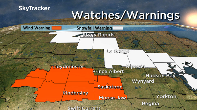
A low pressure system developing over northern Alberta will track across central Saskatchewan early Saturday Morning.
As the cold front swings through, strong northwesterly winds with sustained speeds of 60 km/h with gusts up to 90 km/h are expected to develop.
Winds were expected to diminish below warning criteria during the afternoon hours as the area of low pressure exits the area.
A snowfall warning was issued for the La Ronge, Prince Albert National Park, Pelican Narrows, Uranium City, La Loche and Key Lake areas for 10 to 15 centimetres of snow expected.
Heavy snow will spread into Fort Smith, Fort Chipewyan, and northwestern Saskatchewan Friday night as a low pressure system sweeps across northern Alberta.
Those areas can expect 10 to 15 cm of snow by Saturday morning before the accumulations ease off.
The heavy snowfall will then spread into the La Ronge and Pelican Narrows regions and give accumulations of 15 cm before tapering off Saturday evening.


For weather on the go download the Global News Skytracker weather app for iPhone, iPad or Android.
Wind warning ENDED for:
- Kindersley – Rosetown – Biggar – Wilkie – Macklin
- Outlook – Watrous – Hanley – Imperial – Dinsmore
- Leader – Gull Lake
- Moose Jaw – Pense – Central Butte – Craik
- Swift Current – Herbert – Cabri – Kyle – Lucky Lake
- City of Saskatoon
- The Battlefords – Unity – Maidstone – St. Walburg
- Martensville – Warman – Rosthern – Delisle – Wakaw
Snowfall warning ENDED for:
- La Ronge – Prince Albert National Park – Narrow Hills Prov. Park
- Pelican Narrows – Cumberland House – Creighton
Comments