
Tuesday, February 09, 2016 – Weather forecast update at 4:30 pm:

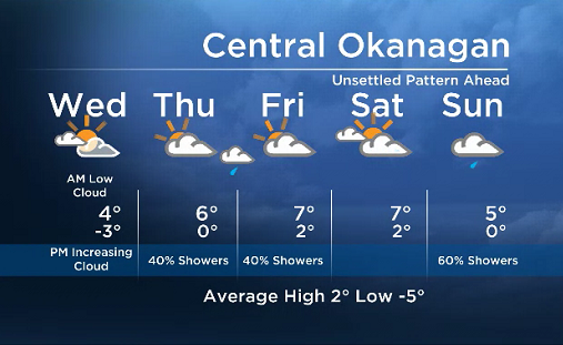
The upper ridge that has been the reason behind our stagnant weather pattern will slowly weaken Tuesday night and Wednesday. Although we will likely see valley cloud/fog development again Wednesday morning, an incoming system from the west in the afternoon will bring in additional clouds at mid and high levels.
Breaking news from Canada and around the world
sent to your email, as it happens.
A front brushing the region will bring a chance of a few sprinkles to the area Thursday, and the unsettled weather pattern will continue into the weekend as multiple systems try to push inland.


Wednesday’s daytime high range: 2 to 7C
We will have the rest of your weather details coming up at 5 and 6:30pm – Hope you can join us!
~ Duane/Wesla
More on Canada
Comments