
WATCH: With so much snow on the ground and so much ice on the Great Lakes, this long cold winter could become a long, cold spring. Global News meteorologist Anthony Farnell explains.
TORONTO — It’s just three weeks until spring.

For those east of the Prairies, it will be a welcome departure from a winter that started off well, but brought a painfully persistent cold during the month of February.
READ MORE: February blahs? Not for everyone across Canada
Environment Canada issues a three-month forecast every month. This latest outlook — for the months of March, April and May — shows that things will be pretty much the same. That’s to say, the forecast looks like it will be somewhat cooler in the east and warm in the west. However, for most of Canada, it will be normal.
“March is going to feel balmy compared to February,” Dave Phillips, senior climatologist with Environment Canada said.
“We’re still numbed by February,” said Phillips citing Ontario and Quebec in particular. “Never has there been a month that cold in central Canada.”
(He added that winter may go down as warmer than normal in areas like Winnipeg and Toronto, despite the cold February, which will undoubtedly be a surprise to most people in the regions.)
But first central and eastern Canada has to get rid of that snow before we see a good solid warm-up.
“I hear a lot of people say, ‘Oh my god, that means another cool summer.’ No, it doesn’t. It doesn’t mean that.”
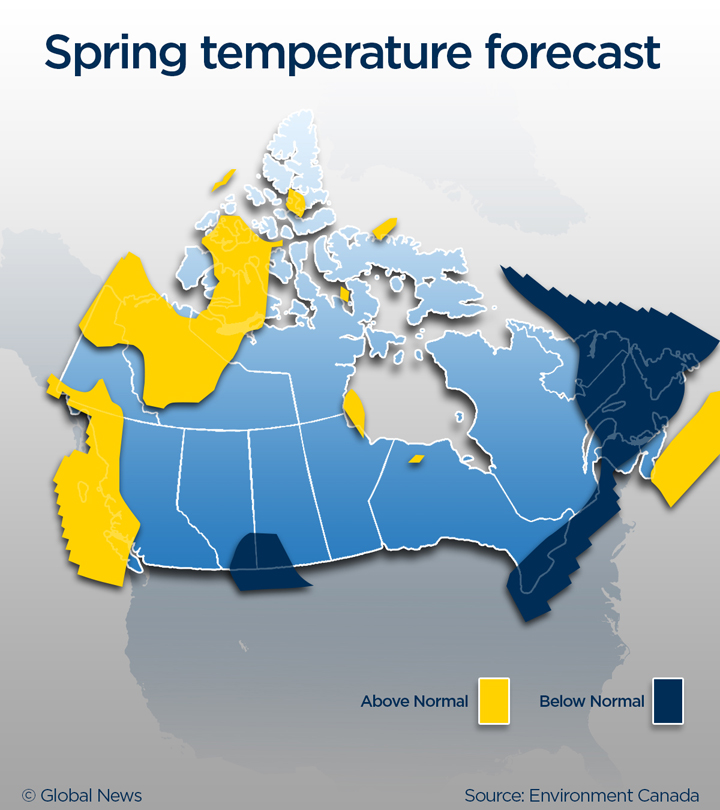
Temperature-wise, Environment Canada is forecasting mostly normal temperatures. But on the coast of British Columbia and in parts of the Yukon and Northwest Territories, temperatures are expected to be above normal. The Prairies will be normal, with the exception of extreme southeastern Alberta and southwestern Saskatchewan, where temperatures are forecast to be below normal.
Once again the east — in an area stretching from southwestern Ontario north to Newfoundland and Labrador — will see colder-than-normal temperatures.
But the key will be to warm up gradually, or we might face some serious flooding issues.
“What we don’t want is a rush to spring,” said Phillips. “Psychologically we do, but we would be much better off if we just eased into spring and not put an end to winter, so we can get rid of this excess snow and unfreeze the ground so nature can get rid of the excess water in a manageable way.”

When it comes to precipitation, once again most of the country looks normal with a few pockets in southwestern B.C. and the east coast experiencing below-normal values. Southwestern Ontario, as well as the Yukon and N.W.T., will see above-normal values.
“There really is a huge difference between what we call an average temperature in February versus March,” said Phillips. “The difference between January and February is typically one degree. The difference between February and March is about five degrees if not more. Everything is relative to that.”
And the good news? Right now Environment Canada models are showing a warmer than normal summer. Let’s hope that nothing changes.
Comments