WATCH ABOVE: A potentially historic snowstorm could dump up to a metre of snow on a large part of the U.S. Northeast. Jackson Proskow reports.

The busy Northeast corridor was in line for a winter wallop that was predicted to bring up to 2 to 3 feet of snow from northern New Jersey to Maine. Here’s what residents of the big cities in the Northeast and mid-Atlantic need to know about the storm:
THE STORM
IN PHOTOS: Empty shelves, long lines as people prepare for blizzard of 2015
The nor’easter was predicted to strengthen off the southern New England coast. Snow was expected to intensify and become heavy beginning Monday afternoon in Philadelphia and central New Jersey, Monday evening in New York City, Monday night in Boston and early Tuesday morning in Maine.
SNOWSTORM VS. BLIZZARD: WHAT’S THE DIFFERENCE?

The National Weather Service issued a blizzard warning for a huge swath of the region, meaning potential whiteout conditions as heavy snow swirls amid gusting wind. The weather service says a blizzard includes sustained or frequent wind gusts of 35 mph or greater and considerable falling snow that lasts for at least three hours. This storm is expected to last up to 36 hours in some locations, forecasters said.
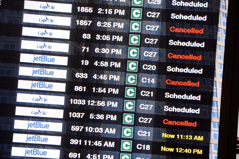
AIR TRAVEL

Airlines canceled nearly 6,000 flights Monday and Tuesday because of the storm. United Airlines canceled all flights in Boston, New York and Philadelphia on Tuesday. New York’s LaGuardia Airport had half its flights scratched Monday. Boston’s Logan Airport and Rhode Island’s T.F. Green were closing Monday evening and no flights were expected to land or take off at either airport Tuesday.
ON THE RAILS

Amtrak cut back on service Monday afternoon. Trains were running between Boston and Washington, but the railroad said passengers should expect fewer trains, especially north of New York.
BIG CITY TRANSIT
In the Boston area, officials were preparing to halt all MBTA transit service Tuesday. In New York, Gov. Andrew Cuomo said New York City will have limited subway service beginning Monday evening and that Metro-North and Long Island Rail Road service will stop later Monday night. New Jersey Transit will shut down late Monday; its train service may not be back until Thursday.
NEW YORK

Up to 2 feet of snow was predicted, with the heaviest snow falling from about midnight Monday through Tuesday afternoon. Winds will be strongest across eastern Long Island. About half the flights Monday at the region’s three major airports were canceled. New York City streets will only be available to emergency vehicles starting late Monday.
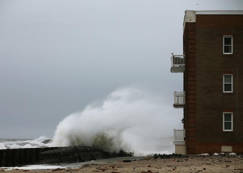
BOSTON


About 20 to 30 inches of snow was forecast for the city and its suburbs, with some locally higher amounts. Near-hurricane force winds were predicted for Cape Cod and the nearby islands. Gov. Charlie Baker banned all non-essential motor vehicle travel beginning at midnight and said 500 National Guard members were on standby.
NEW JERSEY
The central part of the state was expected to get up to 2 feet of snow. Gov. Chris Christie asked people to stay home and only go out if there is an “absolute necessity.” Flooding at the shore was a concern.
HARTFORD, CONNECTICUT
About 20 to 30 inches of snow was predicted, with more possible in isolated spots. Gov. Dannel P. Malloy ordered a travel ban beginning at 9 p.m. Monday and said power outages could top 100,000 in the state.
PROVIDENCE, RHODE ISLAND
https://twitter.com/SeanDalyNews/status/559826926588538883/photo/1
Accumulations of around 20 to 30 inches were expected with locally higher amounts possible. Winds could approach 75 mph. Providence issued a citywide on-street parking ban.
PHILADELPHIA
https://twitter.com/MetroPhilly/status/559793122893639680/photo/1
Snow began falling Monday, but the storm was expected to begin in earnest later in the day. About a foot was expected before the storm ends. Schools in Philadelphia closed at mid-day Monday.
WASHINGTON-BALTIMORE

Washington, D.C., was expected to get up to 4 inches of snow and Baltimore up to 6. The worst of the storm was expected Monday night into Tuesday. The U.S. House postponed votes scheduled for Monday night through Tuesday afternoon.
- RCMP arrests alleged hitmen accused of killing B.C. Sikh leader
- Fall COVID-19 vaccine guidelines are out. Here’s what NACI recommends
- Some 2019 candidates ‘appeared willing’ to engage with foreign interference: Hogue inquiry
- Thousands of Canada’s rail workers have a strike mandate. What happens now?
Comments