

City officials say the torrential downpour that Toronto received “far exceeded” what they expected as crews continue clean up efforts.

“Clearly the amount of rainfall in certain parts of the city far exceeded what we were anticipating with the best information we had,” said city manager Paul Johnson at a press conference on Wednesday on the aftermath of the major storm.
Although power has been restored to most residents and major roads like the DVP have reopened, Johnson said some local roads still have standing water and city crews are working to clear it.
Johnson did note the city is learning from the specifics of the storm and how it can better manage.
“The challenge is much of this city is not designed to handle this amount of water that’s coming down and that’s what we saw yesterday,” Johnson said.
“Most of our buildings and most of our roadways and right of ways are not built to that standard and that would take a tremendous amount of time to change.”

When it comes to damage, the west end of Toronto and areas along the lake were hit the hardest for flooding which saw residents and business owners basements flood as well as loss of power.
“Parts of the city received rain, but not in any volume that would have caused us concern,” Johnson said. “And other parts of the city were literally deluged with rain that was equivalent, I understand, as something like a hurricane amount of water, not the wind, but the hurricane amount of water.”
“As we learn more about these storms, we have to change our approach to how we we we will look at that.”
The Don Valley Parkway reopened on Wednesday morning after the major rainfall caused a portion of the roadway to flood with cars trapped.
The DVP was closed from Bayview Avenue to the Gardiner Expressway but reopened in time for the Wednesday morning commute.

Get breaking National news
More than a dozen people had to be rescued from the flooded area of the DVP and Gerrard, Toronto Fire said.
Major flooding hit the Toronto area Tuesday leaving tens of thousands of people without power after an intense storm passed through portions of southern Ontario.
Toronto Hydro said at the peak about 167,000 people had lost power. As of Wednesday morning, 3,300 customers were still in the dark.
A spokesperson for Toronto Hydro said its believed the outages were due to flooding at a Hydro One transmission station.
Lake Shore Boulevard also flooded, prompting a closure from British Columbia Road to Strachan Avenue.
Toronto rapper Drake posted on Instagram a video of what appears to be yellow-brown coloured water rushing inside of his home with the caption “This better be Espresso Martini.”

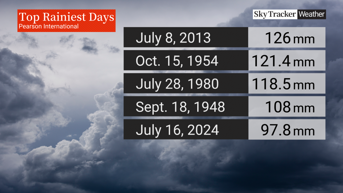
Toronto Pearson Airport said 97.8 mm fell there on Tuesday, making it the fifth rainiest day on record and the highest rainfall in a single day since July 8, 2013.
“During a 10-minute span, we recorded 26 mm of rain,” a post from the airport on X said.
- Strong atmospheric river forecast to hit coastal B.C. as spring break begins
- A blizzard, polar vortex, heat dome and atmospheric river: U.S. faces weather chaos
- Hurricane-strength winds knocked over semi trucks on the Coquihalla Highway
- Fraser Valley cleaning up after windstorm that knocked out power, closed schools


Global News meteorologist Ross Hull said it appears to be the most rain that has fallen in a single day at Pearson Airport in over 10 years since that significant flooding event that occurred on July 8, 2013, when 126 mm fell.
However, Tuesday’s rainfall was the wettest on record for a July 16 in Toronto.
Hull said what occurred from a meteorological perspective was the “perfect storm.”
Much of southern Ontario was hit by torrential downpours for the second straight day with an already saturated ground from heavy rain on Monday.
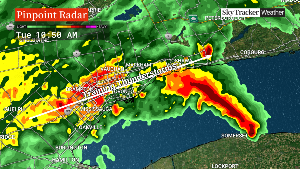
“By Tuesday, the ground was saturated and a line of training storms started forming over the GTA,” Hull said.
“These storms move continually over an area as if on a track — one moves in then quickly is followed by another one. These can often be enhanced by the lake breezes off of Lake Ontario which provides more lift.”
Hull said from around 9 a.m. to just after 12 p.m., a three hour window, more than a month’s worth of rain was dropped over the area.
With the above-normal rain already this month, the sewers and drains couldn’t handle the extra water, he said.
“The saturated ground and infrastructure could not handle it — not to mention all that additional water making its way into the watersheds in a short amount of time leading to rivers and creeks overflowing their banks,” Hull said.
Meanwhile, the City of Toronto tells Global News that it is too early to give firm estimates on clean-up costs or the scope of damage.
“The focus has been on bringing critical infrastructure, like roadways and transit, back online,” the city said. “More updates and information will be available as we examine what was affected and investigate further.”
However, the Insurance Bureau of Canada said preliminary estimates indicate the damage costs could “certainly surpass the $1 billion figure” but that it takes around 45 days from the time of the event to get an accurate number based on claims and damage estimates.
Comments
Want to discuss? Please read our Commenting Policy first.