
Some roads are closed around the province this morning due to mudslides and washouts.

On Highway 31, one lane is now open 27 km north of Kaslo following a mud slide.
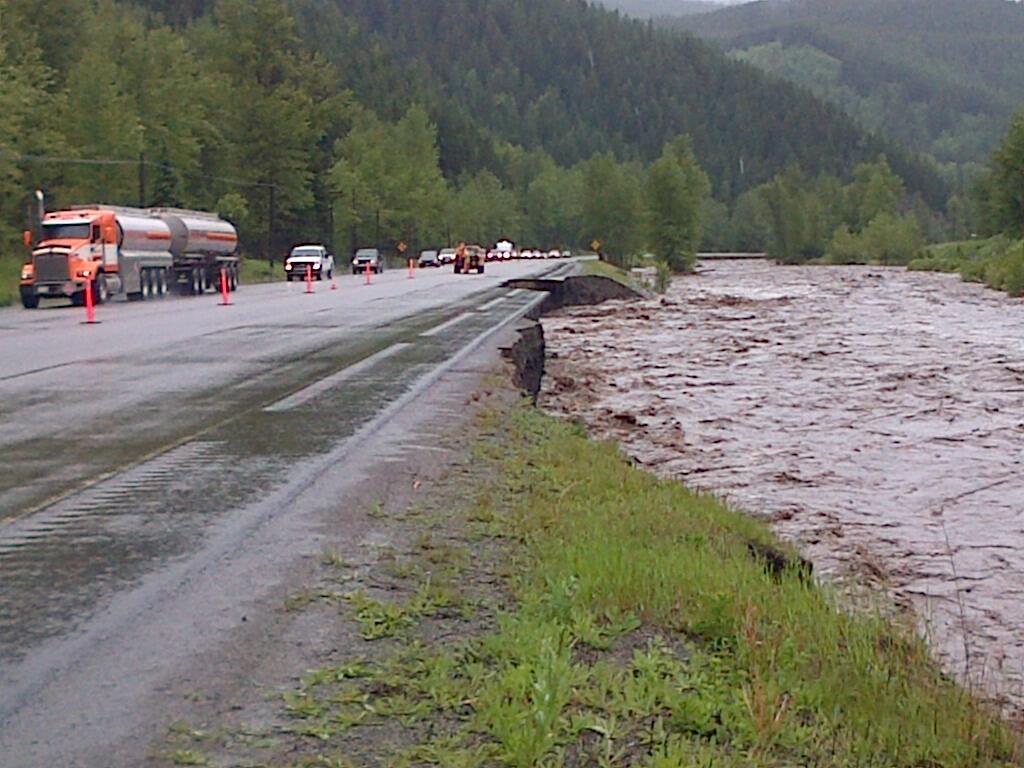
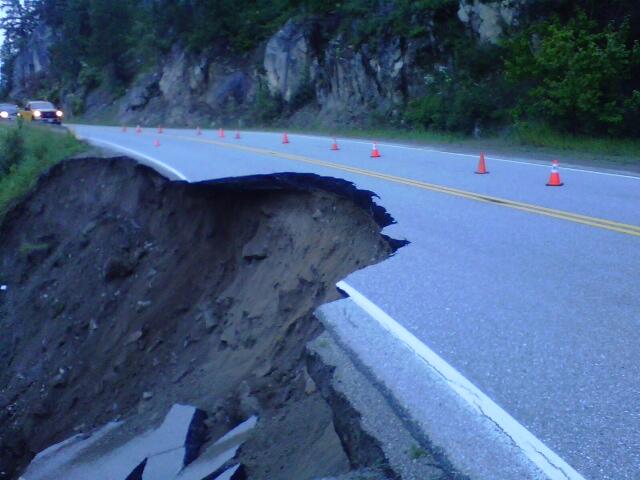
A slide is also affecting a second location on Highway 31, about 13 km north of Kaslo. The road is reduced to single lane alternating traffic.
Highway 31A is also closed in both directions from New Denver to Kaslo (46 km) because of a washout. Drive BC says the estimated time of opening unknown, and an assessment is ongoing.

The Trans Canada Highway east of Golden has reopened to passenger vehicles to Banff. Travelers should still consider using Highway 3 via Cranbrook or Highway 5 via Kamloops.
Highway 93 east of Radium to Castle Junction is closed due to multiple washouts and debris flow sites in Alberta. No detour is available, opening time to be determined.
The washout on Highway 3, six km east of Sparwood is now clear.
Traffic is down to a single lane on Highway 3A due to a slope failure 24 km west of Creston.
Banff National Park has also issued a notice on what roads were open.
Rainfall warnings were in place for the lower third of the province, eastward from the Fraser Valley and Fraser Canyon and south of 100 Mile.
Between 20 and 80 millimetres of rain fell in that part of the province.
Environment Canada reports the Vernon area has already set a one-day rainfall record for June 19, with 17.9 millimetres falling Wednesday, shattering the previous record of 9.4 millimetres, set in 2006.
The BC River Forecast Centre has issued a Flood Warning for Elk River and is maintaining the following High Stream Flow Advisories for the Interior region:
- Elk River (at Fernie) – Flood Warning (UPGRADED)
- Upper Columbia (Kicking Horse River) – High Streamflow Advisory (MAINTAINED)
- West and East Kootenay- High Streamflow Advisory (DOWNGRADED)
- Upper Columbia (small tributary rivers) – High Streamflow Advisory (DOWNGRADED)
- Lower Columbia (small tributary rivers) – High Streamflow Advisory (DOWNGRADED)
- Okanagan (including Mission Creek) – ENDED
- Boundary (including Kettle River and Granby River) – ENDED
- Thompson Region (including the North Thompson, Salmon River, Shuswap River, Eagle River and surrounding areas) – ENDED


The Elk River has continued to rise from heavy rain over the past two days. Current river level at the Elk River at Fernie Water Survey Gauge (WSC 08NK002) is at 4.53m, and rising at up to 10 cm/hour. The Elk River is expected to peak by mid-day or early afternoon today, with an additional 20-40 cm of rise possible. Current river level is approximately 20 cm above the flood of record (1995) at the Water Survey gauge.
On the Kicking Horse River, the majority of the rain from Wednesday has now passed, however rainfall over the past day (approximately 10-20mm) is still working its way down the river, and additional rises are possible through Friday.
Elsewhere, river levels have peaked, and are beginning to recede now that rainfall rates have eased. River levels remain high in the Columbia, West Kootenay and East Kootenay. With drier weather into the weekend, river conditions are expected to continue to improve.


Comments