
Environment Canada warned people in the Calgary area and around southern Alberta about severe thunderstorms that could hammer the region Friday afternoon and evening.

Just before 1 p.m., Environment Canada issued a tornado watch for Lethbridge, Taber, Milk River, Crowsnest Pass, Pincher Creek and Waterton Lakes National Park. Cardston, Fort Macleod and Magrath were added to the list about half an hour later.
A tornado warning was issued at around 2:40 p.m. for the Pincher Creek area near Beauvais Lake Provincial Park, Cowley, Burmis and Maycroft.
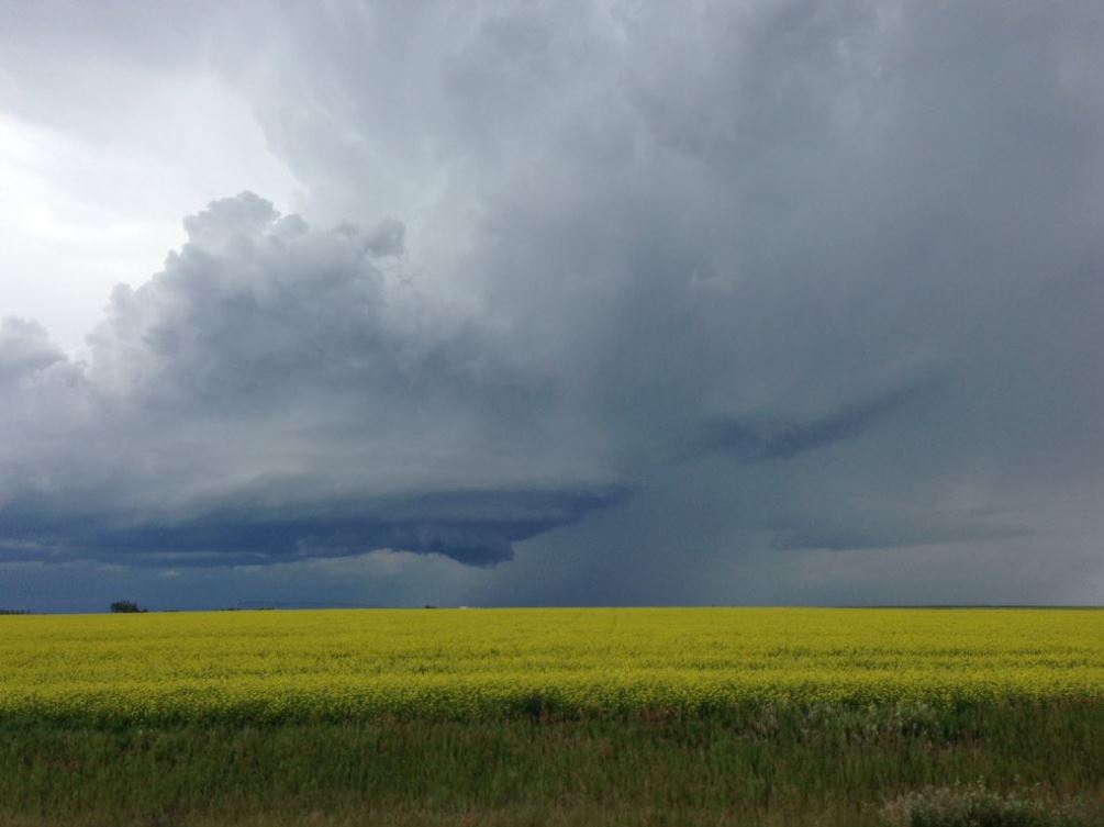
“A rotating severe thunderstorm was located near Beaver Mines, moving northeast at 30 km/h,” Alberta Emergency Alert warned. “This dangerous storm is likely producing very large hail, and may produce a tornado over the next 30 minutes. Communities in the path include: Beaver Mines.”
The M.D. of Willow Creek was added to the list around 4:40 p.m., with a severe thunderstorm capable of producing a tornado moving northeast at 20 km/h towards the community of Granum, near Stavely.
Tennis ball-sized hail was reported to Environment Canada.
At 5:04 p.m. the City of Lethbridge was also put under a tornado warning. It was downgraded to a watch shortly before 6 p.m. All tornado warnings for Alberta were dropped by 6:40 p.m. Friday.
As of 1:20 p.m. Friday, rainfall warnings were in place for Airdrie, Cochrane, Olds, Sundre, Kananaskis, Canmore, Okotoks and Nordegg. At 1:20 p.m. MT, the severe storm was located near Granum and moving north at 20 km/h. Communities in the path included Claresholm.
“An unstable air mass coupled with favourable winds through the atmosphere will create the potential for severe thunderstorms with tornadoes and very large hail. Thunderstorms are developing over southeastern British Columbia and, as they move over the Rockies, these thunderstorms will intensify,” Environment Canada said in a statement.
A severe thunderstorm watch for Calgary was issued at 11:43 a.m. just as dark clouds started to move east towards the city.
City officials said they were releasing some water from the Glenmore Reservoir in anticipation of large amounts of rain coming in. Calgarians can expect to see river levels rise slightly and some pathways under bridges may be flooded.
READ MORE: High stream flow advisories issued for south central Alberta
Environment Canada said in a release that the storms “may be capable of producing very strong wind gusts, hail the size of golf balls, and heavy rain in excess of 50 mm.”
Global Calgary meteorologist Jordan Witzel said the heavy rain is posing the biggest threat in Calgary, with large hail a secondary concern.
WATCH: The Oxford Stomp at Fort Calgary has been cancelled due to weather. Global’s Jayme Doll reports.


The Oxford Stomp, an annual Stampede concert, scheduled from 3 – 10 p.m. Friday was cancelled early in the afternoon.
“Heavy rain and lightning have made the ground unsafe for public occupancy,” a statement on the Oxford Stomp website said. “With the continued rain and hail in the forecast there is not enough time to rehabilitate the site to meet public safety standards.”
The Rotary Club of Calgary and event organizers said they were working through cancellation details, but told Global News there will be no refund for tickets.
The after parties at The Wildhorse Saloon and National on 10th will now open earlier than the scheduled 10 p.m. start time. Attendees can show their tickets at the door for complimentary admission.
Food from the event, including 10,000 meals, will be donated to charity.
WATCH: Global Weather Specialist Jordan Witzel takes you through all the warnings and watches, and why they are popping up.

Severe thunderstorm watches were been issues for Okotoks, High River, Claresholm, Brooks, Strathmore and Vulcan.
“Very large hail can damage property, break windows, dent vehicles and cause serious injury. Remember, severe thunderstorms can produce tornadoes,” Environment Canada warned.
The thunderstorms are expected to move eastward out of the region by the evening hours.
Click here for a current list of watches and warnings around Alberta.
Comments