
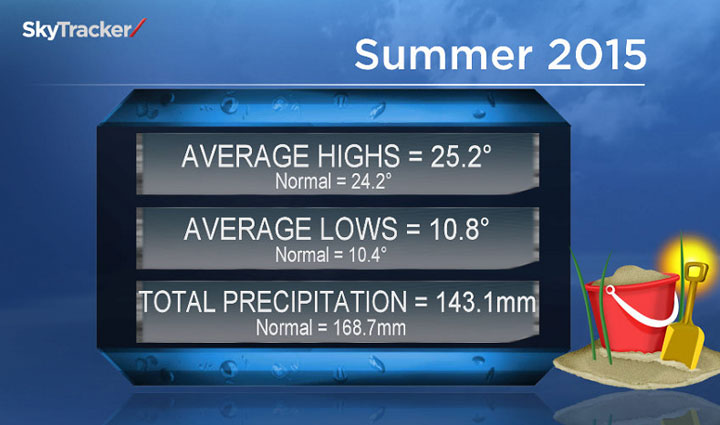
SASKATOON – Summer across central Saskatchewan trended slightly warmer than normal. On average through June, July and August, which makes up meteorological summer, temperatures were approximately 0.7 C above the normal of 17.3 C in Saskatoon.

So far this year, Saskatoon has seen an average number of days above 30 C with 13 days seeing the mercury spike above the 30 C threshold, over three times the number in 2014.
Precipitation-wise, Saskatoon saw an extremely dry June with only 13.6 millimetres of rain falling, when on average 65.8 millimetres fall during that month.
A couple thunderstorms and a major rainfall in late July made up for the deficit with more precipitation falling in a two-day period than Saskatoon saw in the first five months of the year.
Overall throughout the three month period, the city received 143.1 millimetres of rain, which was below the average of 168 millimetres for that time frame.
FALL
Meteorological fall began on Tuesday, Sept. 1; however, the first few days have been well above seasonal.
That trend is expected to change with much cooler temperatures heading into the long weekend and what may be a major rain event moving into full swing by Sunday.
- Life in the forest: How Stanley Park’s longest resident survived a changing landscape
- Buzz kill? Gen Z less interested in coffee than older Canadians, survey shows
- Carbon rebate labelling in bank deposits fuelling confusion, minister says
- ‘They knew’: Victims of sexual abuse by Ontario youth leader sue Anglican Church
The below average trend is expected to continue into the second week of September with the mercury struggling to strive for the 20 C mark by the middle of the week.
Despite the cooler weather ahead, most long range seasonal forecast models are indicating an above normal fall.
WINTER
There is greater certainty in the long range forecast for the winter months this year because of a pattern known as El Niño that will be in full swing by then.
El Niño is a warming of waters in the Pacific off the coast of Peru that has just begun ramping up. It affects the overall placement of the jet stream, which divides warmer air in the south from colder air in the north and is the track most big rain carrying systems take.
El Niño causes the jet stream to track those precipitation-packed systems so far north that the southern Prairies don’t get the moisture we typically get.
READ MORE: Intensifying ‘El Nino’ has surprises in store for Canadian weather
It also typically allows warmer than normal air to flood the southern Prairies.
This year is shaping up to be, historically, one of the strongest El Niños ever recorded, rivaling the one recorded in 1997 that had a dramatic impact on weather globally.
There are numerous other global weather patterns that can influence the large-scale flow that are also being carefully monitored.
Presently, the El Niño pattern has only been stronger twice in recorded history and this year’s is still strengthening and could break all historical records with its effects lasting until spring.
READ MORE: UN’s meteorological agency predicts El Nino event could be among strongest since 1950
The name El Niño means “The Little Boy” or “Christ Child” in Spanish because it was first observed at Christmas.
Current forecasts show a 90 per cent chance El Niño conditions will last through winter until the end of February 2016 and an 80 per cent chance it will be active until April 2016.
For weather on the go download the Global News SkyTracker weather app for iPhone, iPad or Android.
Comments