
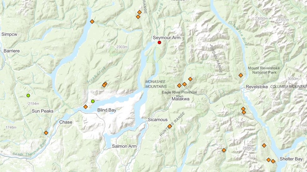
A dozen wildfires discovered on Friday after lightning rolled across the region are listed in B.C.’s Shuswap region.

“Most of these fires are suspected to be lightning-caused,” said B.C. Wildfire Service spokesperson Melanie Bibeau. “We have crews responding accordingly to all of these.”
Bibeau told Global News that most of the fires are considered spot-sized.
Four of the fires are located in a near-perfect line on the north side of Shuswap Lake, across from Sorrento and Blind Bay.
One fire (Hillman Road) is just west of Scotch Creek, not far from Shuswap Lake Provincial Park, with another (Geo Scotch Creek) six kilometres to the northeast, just above Squilax-Anglemont Road.

Get daily National news
That second one was listed as being under control on Saturday morning.

Eleven kilometres to the northeast of that fire, and around eight kilometres north of Celista, are two fires (Onyx Creek South, and Onyx Creek North) that are less than a kilometre apart.
As of Saturday morning, none of those fires had been updated by the B.C. Wildfire Service, with each showing Friday’s estimated size of 0.01 of a hectare.
To the north, a fire is located close to the eastern shores of Adams Lake, near Momich Lakes Provincial Park.


Twenty-five km to the east are two fires (Celista Mountain and NcNomee Creek) north of Humamilt Lake.

Heading slightly south, the Bass Creek fire is located 2.5 km directly east of Shuswap Lake Marine Provincial Park.
Continuing on, 10-17 km northeast of Malakwa are a trio of fires (North Queenie Mountain, Perry River East, Crazy Creek).
And, lastly, 12 km to the east of Sicamous is the King Fisher Creek fire.
This story will be updated as more information comes along.

Comments
Want to discuss? Please read our Commenting Policy first.