
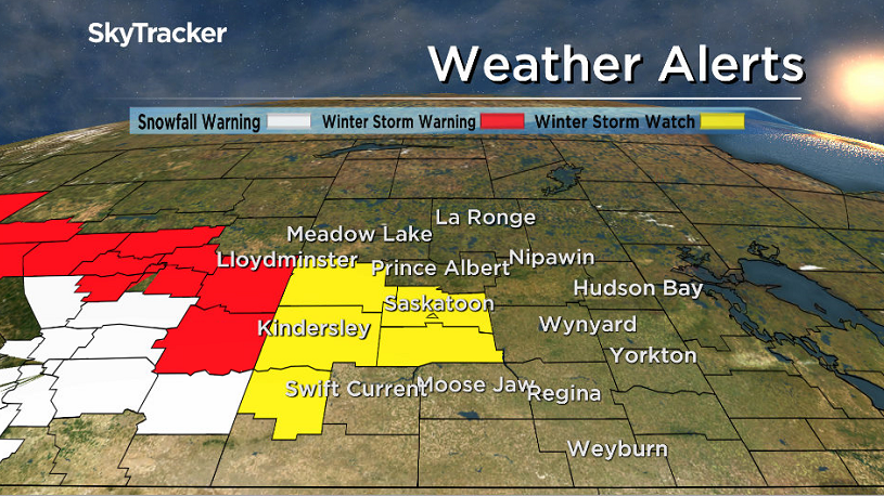
Environment Canada has issued a winter storm watch for Saskatoon and parts of central Saskatchewan for snow and blowing snow developing Friday night.

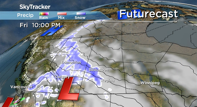
A developing winter storm is forecast to move through Alberta on Friday and spread into western Saskatchewan by Saturday morning with total snowfall amounts of 10 to 20 centimetres possible.
WATCH BELOW: Environment Canada has issued a winter storm watch for Saskatoon and surrounding regions
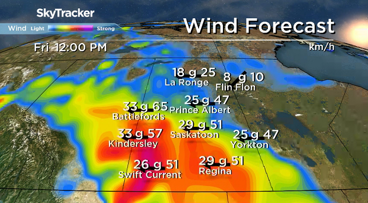
Strong winds of 40 to 50 km/h will combine with the falling snow to produce significant visibility restrictions in blowing snow.
The strong winds and heaviest snow are forecast to taper off by Saturday evening with light snow persisting into Sunday.
Rapidly accumulating snow could make travel hazardous over some locations due to reduced visibility and may contribute to transportation delays.
Motorists planning to head out on roads are advised to use caution and check in with Saskatchewan Highway Hotline before heading out.
For the latest weather alerts download the Global News SkyTracker Weather App for iPhone, iPad or Android.
Saskatoon Forecast
Thursday
March kicked off on a cool note with temperatures dipping back to -20 to start the day with wind chills making it feel like -25 under mostly clear skies.
Freezing fog reduced visibility down to 800 metres at the airport during the morning, but also deposited some beautiful rime frost on surfaces as we warmed up toward minus single digits with some sunny breaks by noon.
Partly to mostly cloudy skies will stick around for the remainder of the first day of meteorological spring, which includes the month of March, April and May, as we continue our climb up into mid-minus single digits for an afternoon high.

Get daily National news
Thursday Night
Cloudy skies roll in with a system pushing into Alberta, which will keep conditions milder, with an overnight low likely just into the minus teens.
Friday
Those clouds will stick around through the day on Friday as easterly winds pick up to 40 km/h with gusts up to 60 km/h possible during the day.
It’ll feel like the -20s with wind chill as you head out in the morning, but by afternoon we should make it up to a daytime high in mid-minus single digits before snow moves in late in the evening and overnight.


Weekend
10 to 20 centimetres of snow is possible this weekend as a slow-moving low pressure system pushes through the province, bringing the majority of the snow to the region on Saturday before it eases on Sunday.

Strong winds will accompany the snow on Saturday, with gusts in excess of 50 km/h possible, which is expected to create treacherous travel conditions with near zero visibility at times and drifting snow likely.


Calmer conditions move in on Sunday with daytime highs dropping a few degrees further into mid-minus single digits and overnight lows diving back into minus double digits.
Work Week Outlook
More snow could push through early next week along with more clouds, potentially bringing a few more centimetres to the region, but overall calmer and cooler conditions will move back in for the first full week of March.

Brittany Janvier took the March 1 Your Saskatchewan photo in Patuanak:

Saskatoon weather outlook is your source for Saskatoon’s most accurate forecast and is your one stop shop for all things weather for central and northern Saskatchewan with comprehensive, in depth analysis that you can only find here.
Comments
Want to discuss? Please read our Commenting Policy first.