

Heat with an upper ridge is set to slide back in, but it will be short-lived.

Weather Advisory
Environment Canada has ended a weather advisory for Flin Flon, Creighton, Fond-du-Lac, Stony Rapids, Key Lake, Wollaston Lake and Southend areas for conditions favourable for the development of funnel clouds Wednesday.
These types of funnel clouds are generated by weak rotation under rapidly growing clouds or weak thunderstorms.
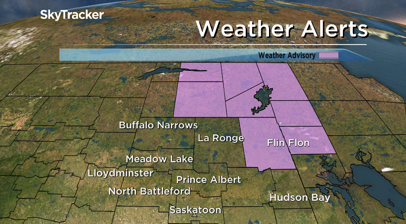
They normally are not a danger near the ground, but there is a chance that the rotation could intensify and become a weak landspout tornado.
READ MORE: What to do when you spot a funnel cloud
For the latest weather alerts download the Global News Skytracker weather app for iPhone, iPad or Android.
Northern Saskatchewan Wildfire Update
Residents of Saskatchewan community have been evacuated after a wildfire just inside Manitoba has caused the closure of the only access to Kinoosao.
Fire crews and the Office of the Fire Commissioner with Manitoba Conservation are working to protect the community and other structures in this area.
The community has been evacuated with the majority either self-evacuating to other communities and approximately five individuals staying in Prince Albert at accomodations arranged by Emergency Social Services/Red Cross.
Pelican Narrows has been “sheltering in place”, moving at-risk populations into a clean air space in the community, avoiding an evacuation at this time.
The McNair fire can be seen from Fond-du-Lac and was within 15 kilometres of the community Wednesday.
The situation in Fond-du-Lac is being monitored by provincial authorities as of Wednesday afternoon.
Rain and thunderstorms are expected in the region Wednesday with heavier pockets of rain possible and winds are expected to blow from the south and west, pushing the smoke and fire away from the community, for the next several days.
As of August 16, 2017, 58 fires active fires are reported in Saskatchewan.
Saskatoon Forecast
Wednesday
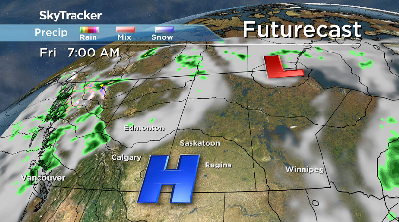
A cold front and system sliding through brought heavy rain to the north and parts of eastern Saskatchewan hit by storms and drew in some cooler air in behind it.
A cool 8 degrees was where Saskatoon started the day under partly cloudy skies, but then sunshine kicked in through the morning, helping to warm us up into the low 20s before noon.
Clouds built in midday, but they didn’t inhibit heating too much with an afternoon high topping out in the mid 20s.
Wednesday Night
Clouds will be in and out Wednesday night with a very slight chance of showers into the early morning hours as we dip back into low double digits overnight.
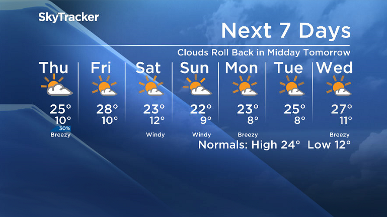
Thursday
Mostly cloudy skies will start the day on Thursday with a slight chance of showers, but skies should clear to bring back some midday sunshine before a few more bubble up with a bit of afternoon instability.
There is a slight chance of showers late in the day as well as we climb back up into the mid 20s with a breezy west-northwesterly wind kicking in and upper level winds projected to bring in some smoke from B.C. wildfires that may reduce air quality during the day.


Friday
An upper ridge slides back in the heat on Friday with a daytime high clambering back up to around 27 or 28 degrees in the afternoon.

The ridge, coupled with a surface high pressure system, will also bring back the sunshine through the day with just a few clouds expected later on.
Weekend Outlook
A cold front is now set to slide through even earlier in the day on Saturday, possibly even before you wake up with a chance of early morning showers.
The rest of the day should see a return to sunshine, but with a cool northwesterly wind kicking in, it’ll be a struggle to get far part the mid 20s both Saturday and Sunday with a few more clouds to finish the weekend.
Bonnie Cross took this Your Saskatchewan photo of paddleboarding with dogs at Jackfish Lake:

Saskatoon weather outlook is your source for Saskatoon’s most accurate forecast and is your one stop shop for all things weather for central and northern Saskatchewan with comprehensive, in depth analysis that you can only find here.
- Life in the forest: How Stanley Park’s longest resident survived a changing landscape
- ‘Love at first sight’: Snow leopard at Toronto Zoo pregnant for 1st time
- Carbon rebate labelling in bank deposits fuelling confusion, minister says
- Buzz kill? Gen Z less interested in coffee than older Canadians, survey shows
Comments