

Winter was way warmer than normal, we’re headed above freezing tomorrow before a cool down ahead.

Warm Winter 2016-17
Meteorological winter ended on Tuesday and meteorological spring (March, April and May) has begun.
Despite the cool start to the season in December that fell slightly below average, the following two months ended up being way warmer than normal.
Overall we were 1.7 degrees warmer than normal this winter.
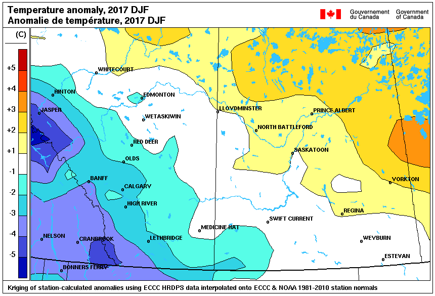
Breaking the numbers down further, daytime highs were 1.2 degrees above normal and overnight lows being 2.1 degrees above average.

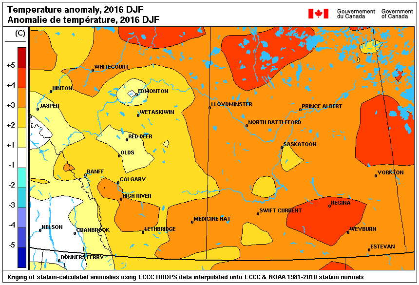
The previous year, Saskatoon had one of the warmest winters on record with temperatures trending 3.7 degrees above average.
It was a dry start to the season with 75 per cent of our normal December precipitation seen and only half of our average amount in January.
February was a bit wetter with almost bang on average for precipitation for the period.
Altogether we saw 72 per cent of our normal precipitation with 26.3 millimetres of rain, melted snow and other forms of precipitation throughout the three-month period when normally we see 36.5 millimetres.
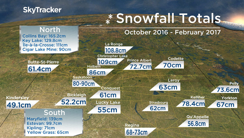
Saskatoon has seen a total of 80 to 90 centimetres of snow from October through to the end of February when our annual normal amount of snow is 90 centimetres.

Saskatoon Forecast
Today
-21 with wind chills down to -27 was where we fell to briefly overnight around 1 a.m. before we warmed up to -17 with wind chills of -23 by morning.
Light snow dominated the first half of the day as we rose up into minus double digits by noon with wind chills just into the minus teens.
The light snow over the area will ease off this afternoon with clouds eventually clearing out later on as we hope to climb to a daytime high just into minus single digits.
Tonight
Mostly clear skies will start off the evening before clouds build back in overnight as we remain fairly mild, only just dropping back into minus double digits as a southerly flow kicks in.
Friday
An Alberta clipper, a fast moving low pressure system that develops in Alberta, develops to our northwest early tomorrow, kicking out ahead of it a warm push of air.


There will be some cloud cover in the morning associated with a warm front with clearing by midday and afternoon sunshine as we climb up to a daytime high above freezing, around +4!
Weekend
Originally we though the warm air would only hang on for Friday into early Saturday, but now it looks like the cold front associated with the Alberta Clipper will swing through later in the day.

The result will be another day with a daytime high a few degrees above freezing before the cold front moves through, which will pick up the winds and bring in a chance of snow into the evening.
There’s a good chance of snow on Sunday with a low pressure system sliding by south of the region as cooler air moves in, dropping us back into minus double digits in the morning with a high in minus single digits.

Weekend Outlook
We may see some lingering snow on Monday under mostly cloudy skies before sunshine returns on Tuesday and a return to cloud cover mid-week.
Afternoon highs are expected to sit in minus single digits with lows in the minus teens and morning wind chills in the -20s throughout the first full week of March.
Shaun Dyok snapped this Your Saskatchewan photo at the Zelma Reservoir:

Saskatoon weather outlook is your source for Saskatoon’s most accurate forecast and is your one stop shop for all things weather for central and northern Saskatchewan with comprehensive, in depth analysis that you can only find here.
Comments