
What a difference a few days make.

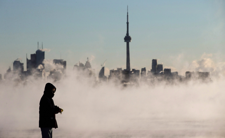
In under two weeks, temperatures across Ontario and southern Manitoba went from seasonal — and even far above-seasonal in parts of Ontario — to positively frigid. In Toronto, the temperature soared to a record-setting 16 C during the day on Feb. 3 to -16 C just 10 days later. And the low was a frosty -26.3 C.
“I don’t think I’ve ever seen a 42-degree difference,” said Geoff Coulson, warning preparedness meteorologist with Environment Canada.
El Niño has been bringing warmer than average temperatures to much of Canada. Toronto and many other cities across Ontario broke records for the warmest December in 2015. And January came in warmer than average as well. Even with the cold days over the weekend, February is on track to remain warmer than normal as well.
“El Niño was expected to be a major player,” said Coulson. “It hasn’t disappointed.”
While El Niño has certainly influenced our winter, bringing milder temperatures across the country, there are other factors as well.
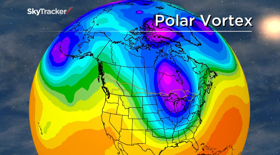
The jet stream is a major influence on weather patterns across our vast country. The upper level flow of air typically travels from west to east. But it doesn’t travel along the same route. It can develop “kinks” where it pulls air up from the south or down from the north.
This year’s mild winter is in stark contrast to the “polar vortex” of the previous two winters when the majority of Canadians faced seemingly never-ending cold. And it’s that polar vortex that made its way back into Manitoba and Ontario this past weekend, pulling down the cold air and reminding us that there’s still a bit more of winter left.
“El Niño is a factor, but there are other things that come to play,” Coulson said.
“Not every single day is going to be an El Niño day, not every single day is going to have that jet stream shoved way up into northern Canada keeping that cold air at bay. We still do have jet stream patterns that have the dips and the peaks, and we certainly got into one on the weekend.”


And that’s what happens each winter. It’s just that this winter has been far milder due to El Niño, and we have forgotten what a normal winter looks like — cold days and somewhat warmer ones.
But then there was that anomaly of 16 C.
That was due to the southerly air being drawn up into Canada from the U.S. And while that tends to happen throughout the year, and certainly in winter, what made this one particularly warm was the fact that the air came up uninterrupted: the ground was far warmer than normal, there was no snowcover that would cool the air as it travelled north.
“Part of that 16 degrees was a result of what had come before with respect to the weather in January and February. I don’t know that it would have been that warm without the winter being what it was before that,” said Coulson.
Normally we’d have had several cold weather days, but that hasn’t been the case for the region. And we’ve also had very little snow: only 26 cm of snow had fallen at Toronto’s Pearson International Airport as of Tuesday morning. The record low for snowfall at Pearson was 42.8 cm set in 2011–2012. Coulson said that the city could see another record-breaker with so little snow having fallen thus far.
So while the cold seemed out of place this past weekend, it’s actually normal. It’s El Niño that has been the anomaly this winter, and perhaps that is giving us a bit of winter amnesia.
Comments