
An intense weather pattern is bringing severe weather to Iceland and the United Kingdom, but what could be arguably the most dramatic effect will be seen in the North Pole.

A storm that is being called Frank brought gale force winds to parts of the northern United Kingdom on Wednesday, according to the country’s Met Office. The low-pressure system is producing wind gusts of anywhere from 88 to 125 km/h, as well as heavy rainfall.
WATCH: Storm Frank batters Ireland and the UK
In Iceland the storm brought high winds — with gusts of 112 km/h in some parts — and rain, which were expected to dissipate in strength Wednesday into Thursday.
The warm air of the Gulf Stream and winds from the jet stream have created what meteorologists call a “weather bomb,” where the central pressure of a storm drops by at least 24 millibars in 24 hours. In this case the storm was far more intense: it dropped by 30 millibars in just 18 hours.
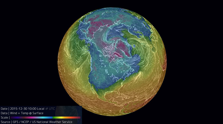
And it’s that storm system that is playing a part in a rapid increase of temperatures at the North Pole — from -30 C to near 0 C. There is a possibility that the unseasonably warm temperatures could last into the new year.


Now, that’s not to say it’s still not cold in parts of the Arctic. As you can see from the illustration above, much of the Arctic is still in the cold, with temperatures nearing -20 C.
In Alert, Nunavut, the temperature was a chilly -21 C on Wednesday, and Resolute even colder at -25 C.
READ MORE: Ski resorts in southern Ontario feeling pain of El Nino year, some opening summer attractions
So though the marked increase in temperature may seem alarming — especially with the National Oceanic and Atmospheric Administration’s forecast that 2015 is to be the warmest year on record, beating out 2014 — it’s important to note that the temperatures aren’t expected to last long-term.
A main driver for unusual weather seen around the world this year — including a Christmas Eve that broke record daytime high temperatures across parts of Ontario — is El Nino, which is shaping up to be one of the strongest ever recorded.
Comments