
Watch the video: Remembering the Barrie tornado 30 years later.

TORONTO – It was May 31, 1985. Though not yet summer, the afternoon air across southern Ontario was heavy with heat and humidity. Temperatures began to reach almost 30 C by the late afternoon in many parts, but there was promise of some relief as a cold front was expected to cross into the area.
READ MORE: A tornado is coming: These are the services that could save your life
While people across the region were coping with the unseasonably hot temperatures, meteorologists at Environment Canada were keeping a close eye on a developing weather pattern. The heat and the humidity, along with that cold front, was a perfect setup for severe weather. Around 2:30 that morning, the weather agency had issued a statement calling for the possibility of severe weather.
“The pattern was recognized as a classic pattern,” Geoff Coulson, a warning preparedness meteorologist said in a recent phone conversation. “This event had the earmarks of a notable event.”
The outbreak
That heat and humidity mixed with the cold front began to trigger storms across southern Ontario. The “notable event” first took shape in Hopeness when an F2 tornado formed at 3 p.m. An hour later another tornado hit Hopeville near Orangeville. And at 4:15, a powerful F4 tornado — with a path that stretched for 115 km — formed in Grand Valley.

Several more tornadoes began to develop around the region. By 4:50 p.m., six tornadoes had formed. But the worst was yet to come.
Barrie resident Mike Montague, having just recently moved to Toronto, was heading back to Barrie on his motorcycle to pick up a few things. The 21-year-old was riding up Hwy. 400 with a friend and noticed that traffic had come to a standstill. Veering onto the shoulder, he approached the Essa Rd. exit.
It was a Friday and congestion on a highway to cottage country wasn’t unusual. But this was different.
“As we came over the crest…that’s when all the visuals started,” Montague said, recalling the day. Tractor trailers were flipped over, cars were facing every which way and horses were even running around the highway.
“I look sometimes and it’s hard to believe what happened that day,” Montague said.
“Every time you see that impending line of dark clouds coming in you stop and wonder how severe it is and what precautions you should take.”
WATCH: How does a tornado form?
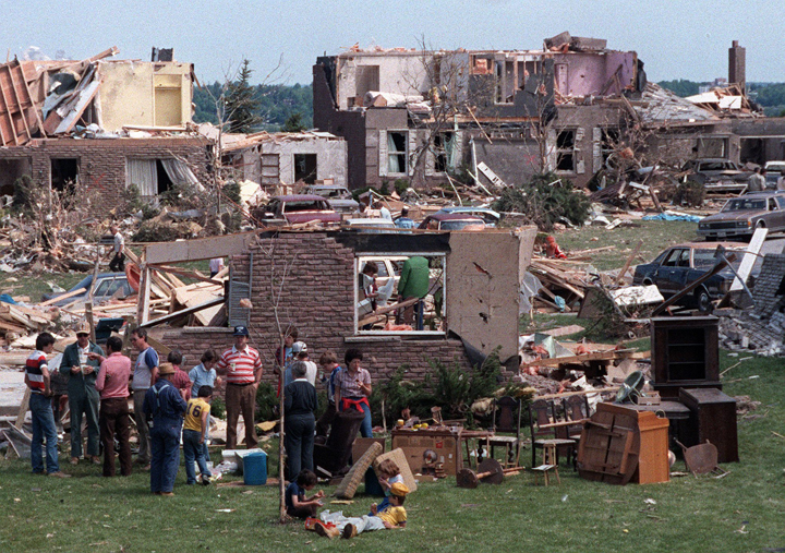
Rick Monkman, retired deputy fire chief of Barrie Fire and Emergency Services recalled the day the tornado tore through the town of Barrie. He was off duty but heard the call go out to emergency services. With only two stations and 35 staff, Monkman headed out.
“When we got up here there was just mass destruction. Houses were levelled, there were still people coming out from the basements of their homes. Horrific injuries.”
The worst part is that no one saw the tornado.


“In the 30 years since, I’ve never seen any pictures of any of the tornadoes,” Coulson said.
The problem was that it was rain-wrapped, hidden in sheets of blinding rain. Many survivors recalled that they just saw a wall of darkness. And you can’t hide from what you can’t see.
Moving forward
In the end, 14 tornadoes crossed southern Ontario over six hours. At one point there were three at a time. The Barrie tornado, an F4 on the Fujita scale, lasted 15 km and was 600 metres wide. It was the most destructive that day, devastating the small Ontario city. Twelve people died, almost 300 were injured, and close to 600 homes and businesses were damaged or lost completely.

The outbreak is a reminder to Ontarians that we are in our own tornado alley. Though we aren’t prone to the more than 1,000 tornadoes our U.S. neighbours get each year, we get our fair share. Some people might be surprised that, globally, Canada comes in second in tornado frequency.
For Ontario, it’s location, location, location: with warm, moist Gulf air to the south carried up to the region and meeting the Great Lakes, the area is in a perfect area for severe weather.
When it comes to alerting the public, a lot has changed since 1985. At the time of the Barrie tornado, only severe thunderstorm warnings had been issued, disseminated on television and radio.
“There was no Internet,” said Coulson. “Now everyone is carrying with them a super-computer in relation to what was available back then.”
This means that not only can meteorologists get images in real-time across various platforms — including social media — but the public can also keep track of any risk of severe weather with news and weather apps.
And the science has come a long way since then, too. Now, Doppler radar is prevalent. Meteorologists now have a better understanding of mechanics of a tornado, the interaction of lake breezes in southern Ontario.
“It’s always in the back of our mind. We know we can get an EF4 level event in Ontario,” Coulson said. “We also know that there’s never been an EF5 event in Ontario, it’s possible as well.”
“We’re using the commemoration of what happened 30 years ago to remind a generation that’s grown up since 1985 that these storms that they think can only occur in the heart of Tornado Alley in the U.S. in Texas and Oklahoma and Kansas, well this level of event could happen here as well.”
- What is a halal mortgage? How interest-free home financing works in Canada
- Capital gains changes are ‘really fair,’ Freeland says, as doctors cry foul
- Ontario doctors offer solutions to help address shortage of family physicians
- Canada will take bigger economic hit than U.S. if Trump wins election: report
Comments