
UPDATE: All advisories mentioned in this story have ended

SASKATOON – Multiple waves of moisture are set to hit Saskatoon in the days ahead, potentially dumping over 20 centimetres of snow on the city by Monday night. A large portion of the snow heading into the weekend will fall at night.
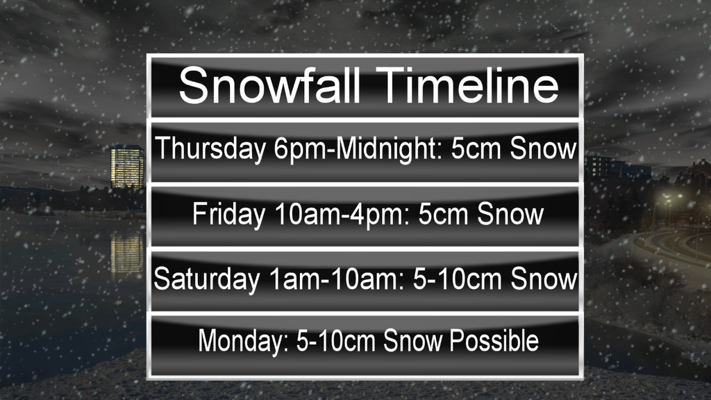
Heavy snow will begin late in the day Thursday and continue into the night with around five centimetres to shovel Friday morning.
After a brief break from the heavy snow through the overnight period and into the morning, it’s expected to pickup midday into the late afternoon Friday.
This batch is also expected to be approximately five centimetres, however with winds picking up to sustained speeds around 30 km/h with gusts into the 50 km/h range, visibility will be reduced and travel conditions are expected to be poor.
Light snow is expected to continue through the evening hours along with the strong winds.
With heavy snow from the previous night and day blowing around, travel conditions are expected to remain treacherous through the night.
Finally, another wave of moisture is expected Friday night into Saturday morning, making for another dump of between five and 10 centimetres of snow.
Snowfall warnings may be warranted for some parts of the province with this batch of snow as many of these areas may exceed the threshold of 10 centimetres of snow or more in a 12 hour time frame.
- Honda expected to announce Ontario EV battery plant, part of a $15B investment
- Trudeau says ‘good luck’ to Saskatchewan premier in carbon price spat
- Canadians more likely to eat food past best-before date. What are the risks?
- Hundreds mourn 16-year-old Halifax homicide victim: ‘The youth are feeling it’
Areas north of Saskatoon, stretching from the Alberta to the Manitoba border are now until a snowfall warning, with 10 cm expected to fall in the warned regions on Friday.
Snow is expected to taper off through the day Saturday and only a chance of flurries is expected Sunday under mostly cloudy skies.
Monday brings a fresh batch of the white stuff, with current models projecting an additional five to 10 centimetres possible that day before conditions start to stabilize heading into the middle of the week.
READ MORE: What would it take to shut down Saskatoon?
The culprit of the blast of winter is a strong low-pressure system sitting in the Pacific Ocean off the coast of B.C. with an intense moisture feed that will drive in warm, moist air over top of the cold, Arctic air mass in place over the Prairies, squeezing out multiple pulses of moisture over the area.
It seems the next few days will make up for the lack of snow so far this winter.
According to Environment Canada records, average snowfall totals in the winter months are around 91 centimetres. So far this winter, the city has received approximately 35 centimetres and over the next few days, we could potentially double the amount seen so far this season.
For weather on the go download the Global News Skytracker weather app for iPhone, iPad or Android.
Visit the Saskatchewan Highway Hotline for the latest road conditions.
Snowfall warning ENDED for:
- Melfort – Tisdale – Nipawin – Carrot River
- Hudson Bay – Porcupine Plain
- Kamsack – Canora – Preeceville
- Île à la Crosse – Buffalo Narrows – Beauval
- Meadow Lake – Big River – Green Lake – Pierceland
- La Ronge – Prince Albert Nat. Park – Narrow Hills Prov. Park
- Prince Albert – Shellbrook – Spiritwood – Duck Lake
Comments