
Rain, wind and record-breaking heat has made for an interesting weather day on the South Coast.

Heavy rain fell overnight and early this morning with a number of floods happening across all areas of the South Coast. The rain was accompanied by strong winds early this morning, bringing down trees and causing major power outages.
Global BC meteorologist Kristi Gordon says rainfall amounts so far have been in the 30 to 50 mm range in the Vancouver and Vancouver Island areas, with another 30 to 50 mm expected to come early tomorrow morning.
WATCH: The Tuesday, December 9 evening weather forecast
Increasing cloud cover will come in late tonight and heavy rain at times between midnight and late tomorrow morning during morning rush hour. Flash floods and pooling water on roads are going to be a concern, says Gordon.
Along with the rain, blustery but very mild southeasterly winds will persist across the Lower Mainland at 40 to 60 km/h tomorrow morning. Wind will ease off by the afternoon.
“Howe Sound will be hit with another 80 mm of rain overnight,” Gordon says. “And the biggest concern as it relates to wind is Vancouver Island, similar to this morning.”
Vancouver Island has a wind warning in place for east Vancouver Island, Sunshine Coast and southern Gulf Islands. Those areas could see southeast winds up to 80 km/hr, power outages will be a concern along with potential ferry cancellations tomorrow morning.
High streamflow advisories have been issued for parts of Vancouver Island and the Central Coast, along with the North Shore, Sea-to-Sky Corridor, Sunshine Coast and Fraser Valley.
A flood watch warning has now been issued for:
- North Shore (including Seymour, Lynn, Capilano, and Coquitlam Rivers and surrounding small streams)
- Howe Sound
- Tsolum River including small streams in the Courtenay-Comox region
- Oyster River (near Campbell River)
- Kingcome River (Central BC, west of 100 Mile House)
The BC River Forecast Centre says streams on the North Shore are prone to flooding in low-lying areas and due to the expected rainfall on Tuesday, flooding may be more prevalent over the next 24 hours. Most rivers will continue to increase throughout Tuesday and are expected to begin to subside by Wednesday morning or afternoon.
River water levels on Vancouver Island and the Central Coast have risen substantially overnight. Flows on the Tsolum River and the Oyster River are now above the 10-year flood level and are expected to continue to rise today, potentially exceeding the 20-year flood level.
The Kingcome River is currently at 6.5-meters and is rising at approximately 10 centimeters per hour. The river is expected to peak late Tuesday above the flood stage at 8.6 meters. An additional 140 mm of rain is expected over the next 48 hours.
Environment Canada says localized flooding in low-lying areas is possible.
Residents are asked to watch for possible washouts near rivers, creeks and culverts, and are advised to keep children and pets away from creeks and river banks.
The weather conditions caused a number of ferry cancellations this morning. For a detailed list, go here.
Over 11,000 BC Hydro customers were without power in the Lower Mainland and Sunshine Coast.
In North Vancouver, geotechnical crews are keeping a close eye on the site of a rockslide over the weekend. Crews say conditions are considered stable at this point. Potential for flooding arising from the rock slide remains low. Trail closures, including the Homestead, Fishermans and Twin Bridge trail, remain in effect and may be extended to include other areas.
In Delta, crews are dealing with a partial collapse of a dike on Seaview Road, just off 67th Street in Tsawwassen. One home has been evacuated. Crews are scrambling to make repairs and stop the flooding.

In Surrey, a giant tree collapsed onto the roof of a house in the 6500 block of 152 Street.


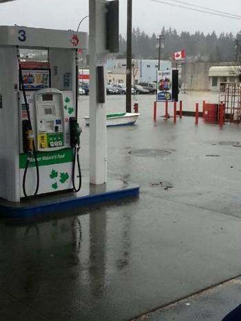
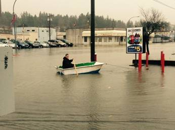
Meanwhile, there is extensive flooding in Port Alberni.
There are currently more than 1,500 people in the area without power at this time and some areas might not be restored until 4 p.m.
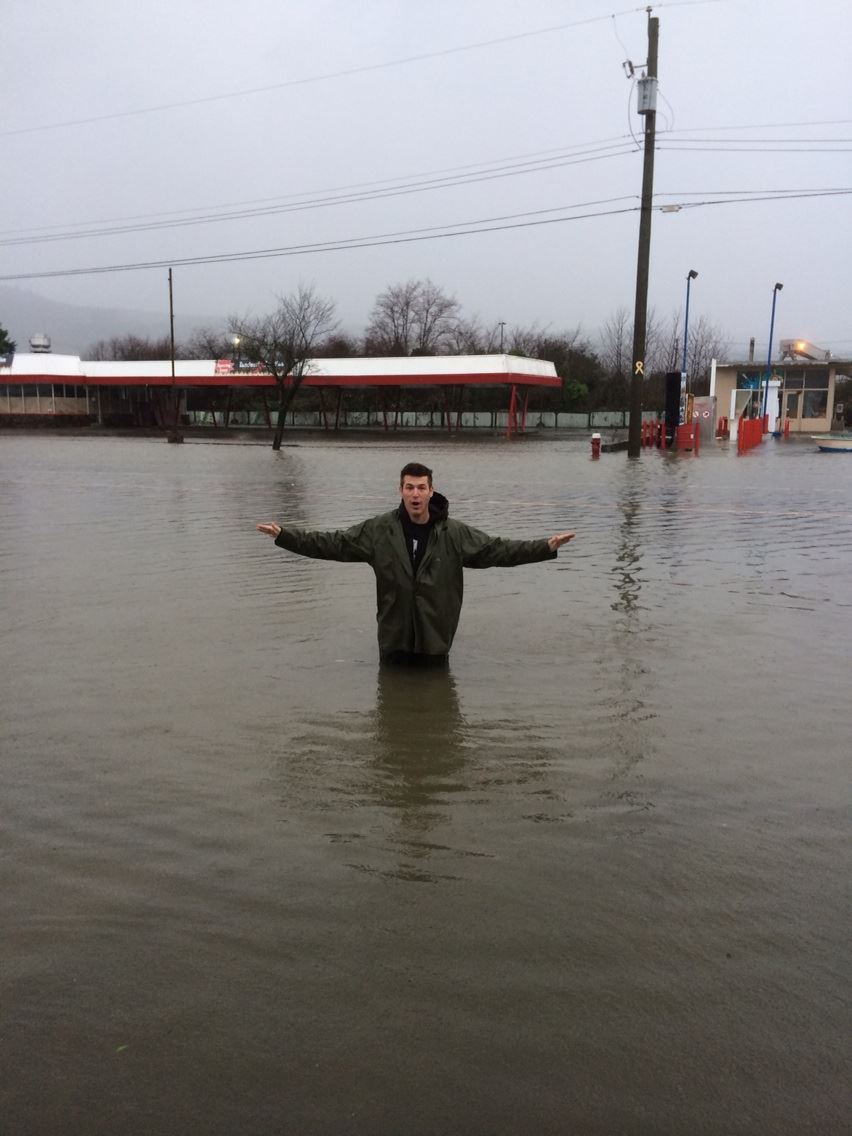
The worst flooding appears to be in the area of 3rd Avenue and Bute Street with one resident standing up to his waist in the water.


The city of Courtenay has now declared a state of emergency because of the flooding. The city says there are some road, facility and trail closures due to flooding in some low-lying areas.
Roads
- Comox Road CLOSED from Highway 19A bypass (by Kia dealership) to Headquarters Rd.
- 5th Street Bridge CLOSED
- Dove Creek Road is CLOSED at the Dove Creek Bridge
- Puntledge Road is CLOSED
Facilities
- The Lewis Centre is CLOSED temporarily (parking lot is flooded)
- The LINC Youth Centre is CLOSED
Trails
- The Courtenay Riverway / Airpark Walkway is CLOSED


Comments