


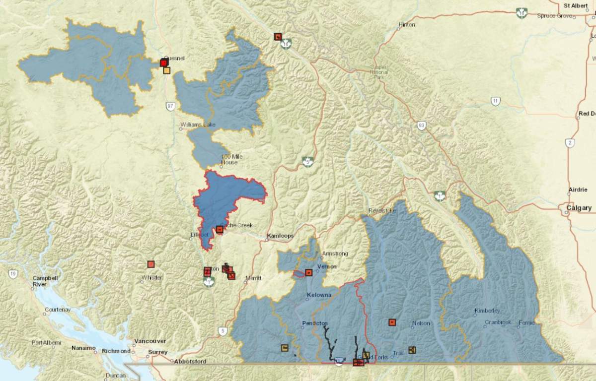
Residents in B.C.’s Southern Interior awoke to rain on Saturday morning, along with flood watches and warnings still in effect from earlier in the week.

Just before midnight on Friday, Environment Canada issued a special weather statement for the Okanagan, Boundary and West Kootenay regions, stating that heavy rain could contribute to the escalating flooding situation.
The weather agency added that mudslides are also possible, stemming from heavy rainfall on melting mid-to-high-level elevation snowpacks.
“Showers at times heavy will develop tonight as the first of multiple systems arrives,” said Environment Canada. “By Saturday afternoon, showers will intensify with embedded thunderstorms further increasing precipitation amounts.”
It added that “the threat for sudden heavy downpours and flash flooding on top of the volatile spring snowmelt conditions remains.”
The rainfall is expected to last through to Saturday night, with warnings stretching from the Central Okanagan through to Kootenay Pass.

The River Forecast Centre has most of the Southern Interior under a flood watch, which is when river levels are rising and will approach or may exceed bankfull.

Get breaking National news
However, the Boundary region is under a flood warning, which is when river levels have exceeded bankfull and that flooding will occur.
In Grand Forks, 21 properties are on evacuation order, while nearly 900 properties in the Salmo area are on evacuation alert. Five years ago, the community suffered extensive flooding damage.
The town’s mayor, Everett Baker, said Saturday’s rain wasn’t as heavy as projected, which is good news, but it’s still raining.
“It’s been pretty steady and was throughout the night. And it looks like it’s going to continue today,” he told Global News on Saturday morning. ““The Granby River is up, the Kettle River seems to be up a little more.”

The mayor said there is flooding in the Johnston flats area, where homes are under evacuation alert, “and it looks like we’ll be moving that to an evacuation order.”
Baker said there could also other extra evacuation alerts, and possibly orders, issued on Saturday as well.
- Flooding concerns, tornado threats sweep across Canadian Prairies
- Edmonton police shoot man dead after alleged assaults during hit-and-runs
- B.C. premier visiting China to pitch LNG project as province’s ‘really big fish’
- Canada’s first offshore wind farms move closer to reality as regulator clears bidders


“We’ve got some concerns,” said Baker. “But where we’ve done flood protection over the last few years, they seem to be holding at this point. It seems to be working and that protects downtown core and our industrial area.”
The mayor noted that the town has put out 35,000 sandbags, 35 dump trucks of sand and 3,000 feet of tiger dams.
In Salmo, the village’s mayor, Diana Lockwood, said water levels are slowly going down, but they’re not ready to end the evacuation alerts.

In Cache Creek, one home was said to be destroyed by flooding while others have been damaged.
“I recently signed an order extending the state of local emergency for another week,” said Cache Creek’s mayor, John Ranta.
Meanwhile, the River Forecast Centre said
“We’ve gone from several days to a week of hot weather, and that has really accelerated snowmelt,” said Dave Campbell of the RFC. “And we’re seeing the runoff and the rivers have come up in response to that transition in the weather. We’re starting to see rain on the ground now.”
More information about current flood advisories is available online at EmergencyInfoBC.

Comments
Want to discuss? Please read our Commenting Policy first.