Satellite Imagery
-
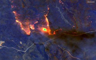
Australia wildfires from space: Satellite photos show scope of infernosThe wildfires, which have been raging since September, have so far burned through eight million hectares of land across the country.WorldJan 6, 2020
-
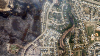
Alberta government releases new app showing Fort McMurray wildfire damageFort McMurray residents wanting to survey the property damage left behind by the devastating wildfires can now do so through a satellite imagery app released by the province.CanadaMay 15, 2016
-
-
Advertisement
-
NASA sees Fort McMurray wildfires from spaceThe devastating wildfires that forced more than 80,000 people from their homes in Fort McMurray has been imaged from space.EnvironmentMay 5, 2016
Trending
-
Life in the forest: How Stanley Park’s longest resident survived a changing landscape17,407 Read
-
Meet the man who’s lived 30 years in Stanley Park16,213 Read
-
Gas prices surge in some parts of Canada. What’s causing pain at the pumps?13,743 Read
-
Iran fires air defences at military base after suspected Israeli drone attack11,717 Read
-
Did cloud seeding cause Dubai flooding? What to know about the science10,560 Read
-
Woman who wheeled a corpse into bank to co-sign a loan arrested9,733 Read
-
Top Videos
-
How Stanley Park’s longest resident survived for more than 30 years in the park
-
Man lives in Stanley Park for more than 30 years
-
What is driving the sudden spike in gas prices in Eastern Canada?
-
Israel reportedly launches strikes into Iran, air defences destroy drones in Isfahan
-
Did cloud seeding cause Dubai flooding? What to know about the science
-