
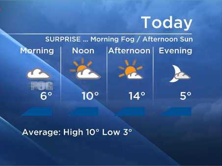
Good morning – we still have that morning inversion weather pattern that is susceptible to fog and valley cloud.

At 5am this morning, the weather balloon that gets released out of the Kelowna airport reported 5 degrees at the valley bottom and it was 11 degrees at over 1500 metres.
When air is warmer aloft, there is little atmospheric mixing because the air is so stable.
Under a normal circumstance where the air cools with height, the cold upper air sinks and the warm lower air rises creating a situation where the air can mix.
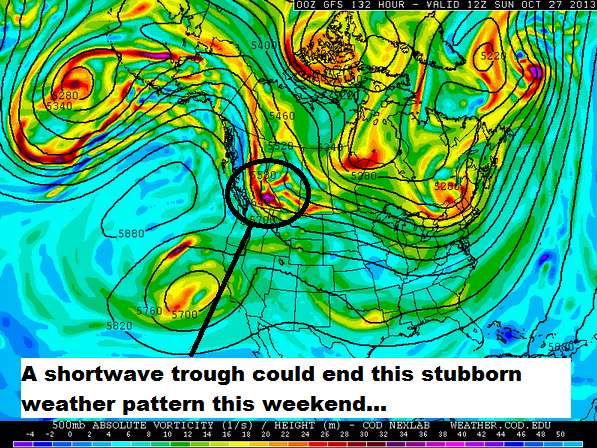
This upper ridge that has been over us for over a week now has created this very stagnant and slack weather pattern and until a frontal system or a storm hits us to cool down the air at the upper levels, or until we get some strong winds aloft, this situation is going to continue.
Right now some of the weather models suggest a little shortwave that will move across the area this weekend that could help stir up the air and end this stubborn weather pattern. Until then you can expect… you guessed it… morning cloud/fog and afternoon clearing (in most places).


 Temperatures will be above seasonal in the Boundary/ Okanagan Valley with highs 13-17C, however some areas in the Shuswap and Arrow Lakes region will not see the clouds clear and as a result it will be a few degrees cooler for those areas.
Have a great day! Tune in at 5pm, 6:30pm and 11pm for the rest of your weather details.
~Wesla/Duane
- What is a halal mortgage? How interest-free home financing works in Canada
- Capital gains changes are ‘really fair,’ Freeland says, as doctors cry foul
- Ontario doctors offer solutions to help address shortage of family physicians
- Canada will take bigger economic hit than U.S. if Trump wins election: report
Comments