

Anthony Farnell is Global News’ Chief Meteorologist.

Weather talk is nothing new amongst Canadians, but I’ve never seen so much gossip about an upcoming winter season.
It was a hot and humid early August day when I was first approached and asked if the rumours were true. Would this be one of the worst winters we’ve ever seen?
I was caught off guard and answered that winter was still months away and it was way too soon to talk about this. In the months that followed, voices saying “cold and snowy” have grown louder and louder, but is this just chatter or something more?
Let me start by saying that while skills in long-range predictions are improving, meteorologists making seasonal forecasts are sometimes wrong.

This is understandable, considering what goes into making these predictions.
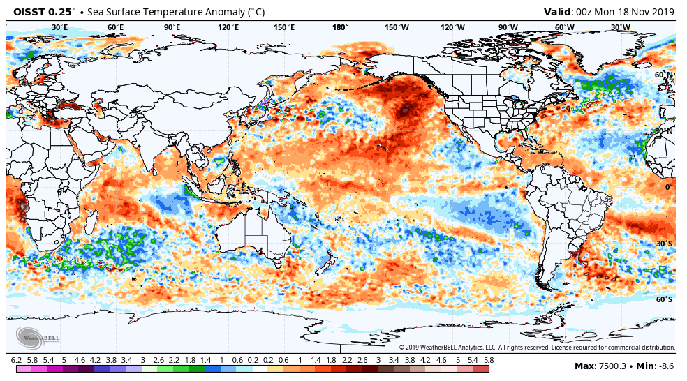
We rely on computer models, global sea surface temperatures, recent climate trends and current weather patterns to predict months in the future. With so many variables there are bound to be different outputs, but this winter, most of them are pointing us in the same direction.
This gives me increased confidence that it will indeed be a cold and snowy winter for a large chunk of the country. As for “worst ever,” I’m not going to that extreme.
Atlantic Canada
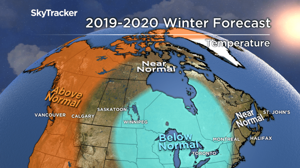
The centre of the Arctic air should stay west of the Maritimes this winter, but like an unwelcome guest, it will make frequent appearances. My forecast calls for near seasonal temperatures, but this will likely come in the form of wild swings. The water off the east coast is mild and this should enhance rain and snow amounts in storms.
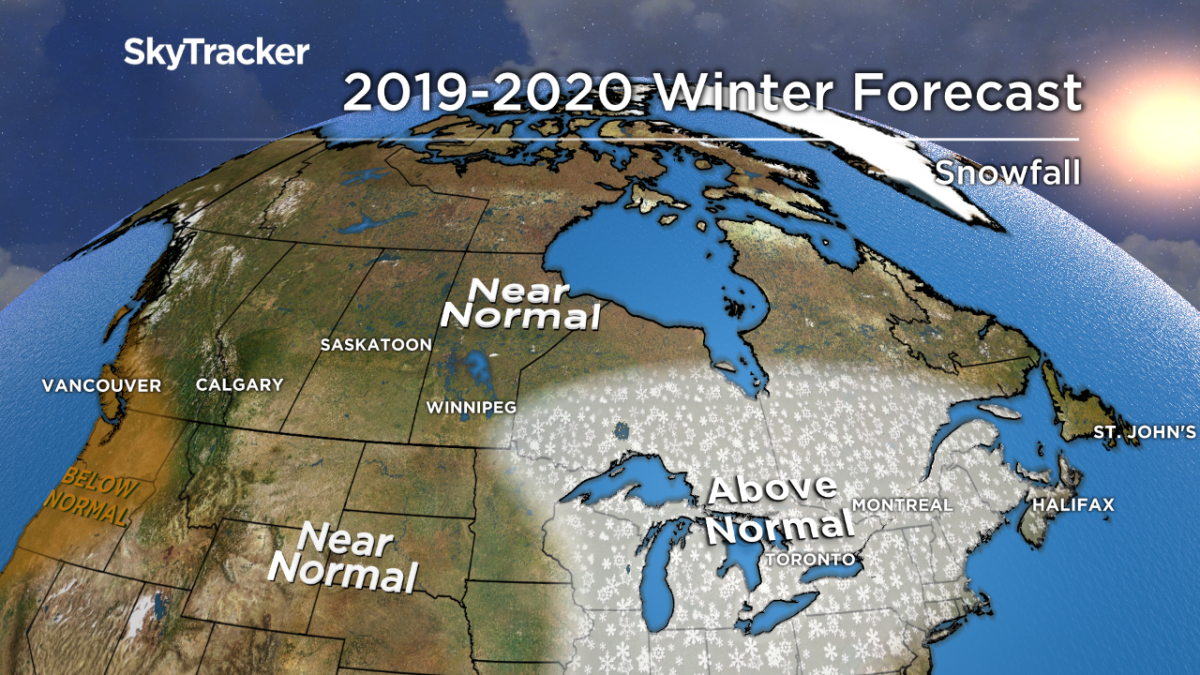
I’m calling for above-normal snowfall for New Brunswick, PEI and Nova Scotia, with near-normal amounts for Newfoundland and Labrador.
Ontario and Quebec
For the second year in row, snow and cold arrived early in November and led to another record early start to the ski season at some resorts. The weather will be moderate for a time, with a back and forth pattern lasting through at least early December before sustained cold can hold on.
This still sets the stage for a snowy holiday season. The real winter pattern arrives in January and February where Arctic air will funnel in below-normal temperatures with plentiful snow thanks to an active storm track.
I also predict significant lake effect around the Great Lakes. The recent trend of winter weather lingering into spring will continue with a chilly and potentially snowy March and April likely.
Prairie Provinces
Big swings in temperature are nothing new for the Prairies and this fall has been a prime example.
The region sees cold and snow as early as late September, followed by a stretch of mild and sunny weather, then back to cold and snow — repeat.
Much like last winter, the further east you go, the colder in relation to normal it will be this season.
READ MORE: In Winnipeg, The coldest days of November are behind us


The west coast upper level ridge will occasionally spill over the Rockies, bringing bouts of Chinook winds to Alberta.
Low-level Arctic air will be harder to miss in Manitoba, where the possibility of another very cold January or February exists. Snow will be near average for most areas, with the exception of southeastern Manitoba.
British Columbia
A weak El Nino is playing out in the tropical Pacific, but a large, more ominous warm water feature is just off the west coast.
This “warm blob” has blossomed once again which favors ridging that should extend north to Alaska for much of the winter.
The highest likelihood of significant snow in B.C. will be in December, before the ridge — also known as a block — develops, and on occasion when it breaks down.
Even with milder temperatures and below-normal snowfall forecast for the mountains, I’m not predicting a bad ski and snowboard season. The snow base will build quickly in December and without a “Pinapple Express” or “Atmospheric River” connection in storms, melting will be less common.
READ MORE: B.C.’s winter weather outlook: It’s going to get interesting
Yukon, Northwest Territories and Nunavut
Another mild winter is likely across Yukon, the Northwest Territories and northern Nunavut. Reduced sea ice and a sun entering its 11-year solar cycle minimum make this northern warmth and “blocking” more common. This setup also helps displace colder air further south into southern Canada and the United States.
No strong signal of above- or below-normal snowfall exists, so I have kept this area near normal but with low confidence.
Comments