A municipal official in Nova Scotia’s Cumberland County wants the province to test the ground stability beneath a section of the Trans-Canada Highway adjacent to several sinkholes.

Oxford, N.S., chief administrative officer Rachel Jones says recent laser imaging shows sinkholes in a band crossing the highway.
And an aerial image from the 1930s, before the highway was built, indicates it crosses an area where there had been a hole filled with water.
READ MORE: N.S. road crews checking highways near Oxford for sinkhole problems
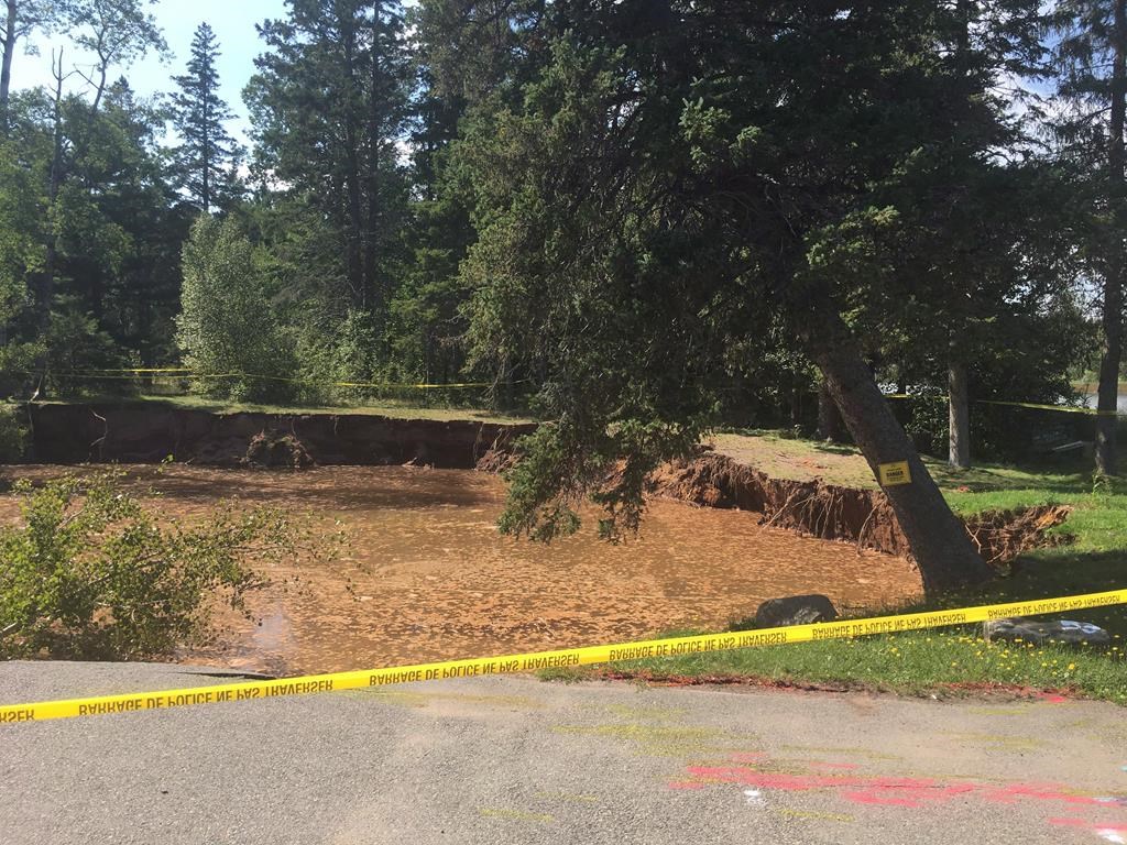
A large sinkhole that opened last year and has since filled with water forced the permanent closure of the Oxford Lions Club building and a surrounding park. A report released last week by an engineering firm warned of the risk of additional sinkhole activity, including near Highway 321, which runs through the town.
Jones says a recommendation that was not included with the study says the testing area should be extended to the Trans-Canada.
Jones said that a recommendation report that was not included with the study said the testing area should be extended to the Trans-Canada, which is also known as Highway 104 in Nova Scotia.
While not all sinkholes are the same or pose the same risk, Jones said she believes there should be testing near the highway to determine exactly what’s there, given it’s a major transportation link.
- Singh mulls TikTok return as U.S. nears potential ban over security fears
- EV sales in Canada rose in recent years despite higher interest rates. Why?
- Possible TikTok ban in U.S. looms after Biden signs bill, setting up legal fight
- 2021 heat dome fuelled by climate change, intensified wildfire risk: study
“We raised this issue a year ago that it was a concern,” she said. “Because the lidar mapping shows that whole topography going through that whole section, it’s unclear the stability of what’s underneath that section of the 104. I think it’s going to be really important to do some benchmark testing.”
READ MORE: Study says some areas in Oxford, N.S., face high risk of developing additional sinkholes
Transportation Minister Lloyd Hines told reporters Thursday that road crews are conducting daily checks of the highway conditions in the area, while data is being collected to determine whether any action needs to be taken.


A geologist with the provincial Department of Energy and Mines has said preliminary results from the laser imaging show a well-defined line of sinkholes in and around Oxford, extending for about five kilometres and reaching a width of about 500 metres in some areas.
Amy Tizzard, the geologist, said in an interview last week that the number of sinkholes within the belt numbered in the hundreds “if not a thousand.”
She cautioned that there are many types of sinkholes, including some that are more slowly subsiding and some that are more rapid like the one in the parkland next to Oxford’s Lions Club.
That depression is classified as a cover-collapse sinkhole, where groundwater has dissolved underlying materials such as salt or gypsum to create a void that eventually leads to a collapse of the ground above.
Jones said what happened in Oxford is the basis for her concern about the highway.
“You don’t know what you don’t know,” she said. “We didn’t know that there was the potential of a cover-collapse sinkhole in the middle of the parkland …. I would not want to see anything like that happening on the Trans-Canada.”
Comments