

Strong storms continue to plague the forecast across Saskatchewan.

Storm report
A wild weekend of weather was reported across Saskatchewan with numerous severe and tornado-warned thunderstorms marching through the province.
Environment Canada confirms an EF0 tornado touched down roughly seven kilometres northwest of Northgate on Friday at 4:15 p.m. with estimated wind speeds of 90 to 130 kilometres per hour and no damage reported.
A funnel cloud was spotted just northwest of Saskatoon on Saturday morning, lasting a few minutes before retreating back into the base of the cloud.
There was also reports of a funnel cloud south of Eatonia on Sunday, ping-pong ball sized hail at Luseland on Sunday afternoon and wind gusts southwest of Saskatoon of 100 km/h at 9:35 p.m. on Sunday.

Major damage was also reported in the Eston area with power remaining out to much of the town into Monday morning.
Weather forecast
Monday
Comparatively, the work week started off on a much more settled note after a few thunderstorms early Monday morning as temperatures dipped down to 13 degrees to start the day.
Mostly sunny conditions prevailed through the morning as temperatures returned to the low 20s before heading for the mid-20s in the afternoon with a chance of thunderstorms in Saskatoon as Regina stays mostly sunny.
Monday night
The mercury dips back into low double digits Monday night as skies clear back out and fog patches develop into the early morning hours.
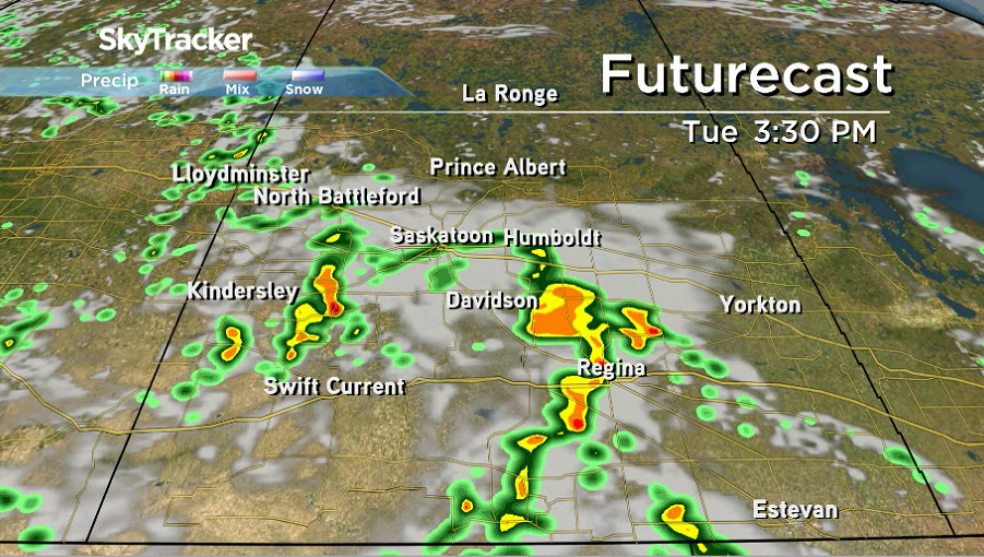
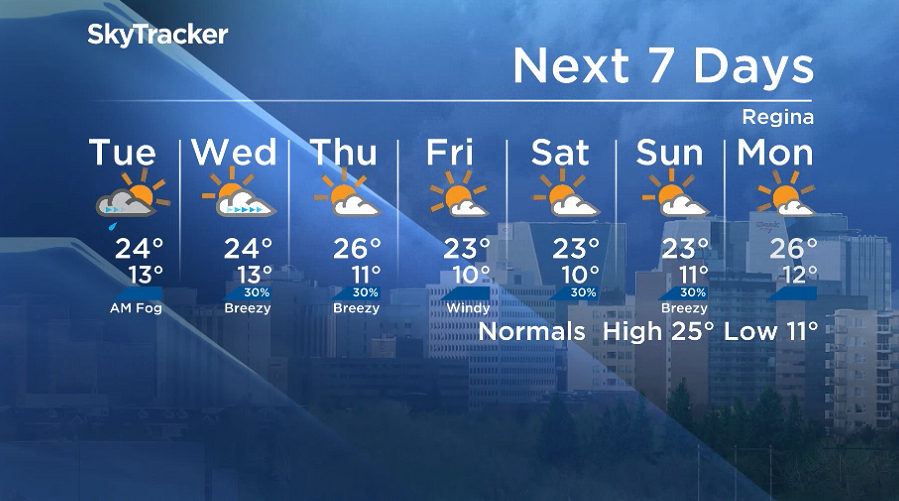
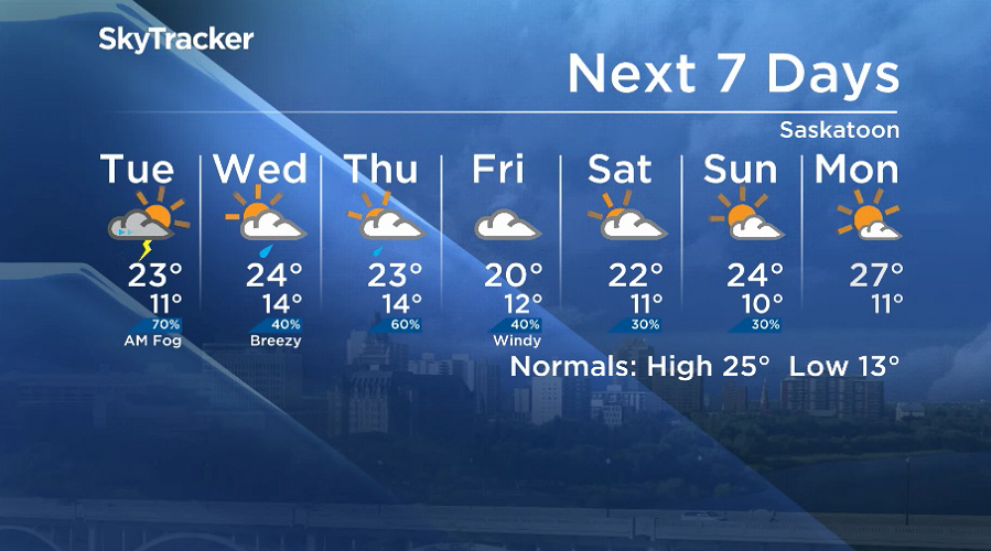
Tuesday
After some sunshine to start the day, a low-pressure system pushing into the province on Tuesday will bring a return to unsettled conditions with a good chance of thunderstorms in the afternoon and evening.
Temperatures should manage to make it up into the mid-20s in the afternoon before some slight cooling behind showers and storms as they slide through.
Wednesday-Friday
There could be some lingering showers behind the system early Wednesday before clouds clear out later in the day but return with a good chance of storms Thursday and rain on Friday in Saskatoon as Regina stays sunnier.
Daytime highs will return to the mid-20s until Friday as they fall back a few degrees toward the low 20s with cooler air pushing in from the north.


Weekend outlook
The third weekend of July is shaping up to hold a few clouds with a chance of showers in the Saskatoon area on Saturday with sunshine in Regina that will also kick into Saskatoon on Sunday as highs stay in the low-to-mid 20s.
The Your Saskatchewan photo for July 15 was taken by Wayne Busch near Nokomis:

The Saskatchewan weather outlook is your source for the province’s most accurate forecast and is your one-stop-shop for all things weather with comprehensive, in-depth analysis that you can only find here.
For weather on the go, download the Global News SkyTracker Weather App for iPhone, iPad or Android.
- Trudeau says ‘good luck’ to Saskatchewan premier in carbon price spat
- Canadians more likely to eat food past best-before date. What are the risks?
- Hundreds mourn 16-year-old Halifax homicide victim: ‘The youth are feeling it’
- Vacation death: Cuba apologizes after Canadian family receives wrong remains
Comments