
Light rain started the day on Thursday throughout the Okanagan, as a moisture laden system pushed north from Washington state.

Temperatures started the day around 11 degrees before rising into the mid-teens by midday. The afternoon high is projected to be in the upper teens or low 20s, as rain starts to ease to just a slight risk of a thunderstorm.
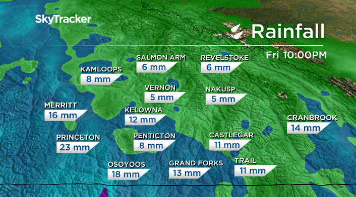
Rain picks back up Thursday night, with the heaviest and steadiest precipitation expected early Friday morning before it starts to ease during the day.
Temperatures will start the day around 11 degrees before climbing into the mid-teens for an afternoon high, with 5 to 15 millimetres of rain possible by the end of the day.

Showers become spottier to kickoff the long weekend Saturday morning, with afternoon sunny breaks possible as the mercury makes a break for the upper teens.
Sunshine is expected to make its marvelous return Sunday morning before a few clouds build back in, with a slight chance of showers to end the day as temperatures climb toward the 20s in the afternoon.


Twenty-degree heat is expected to return again in the afternoon on Victoria Day Monday, with partly-to-mostly cloudy skies and a small chance of showers.
A gradual warming of daytime highs will take place for the short work week ahead, with afternoon highs returning a few degrees into the 20s under mostly cloudy skies with a risk of showers here and there.

For weather on the go download the Global News SkyTracker Weather App for iPhone, iPad or Android.
- Honda expected to announce Ontario EV battery plant, part of a $15B investment
- Trudeau says ‘good luck’ to Saskatchewan premier in carbon price spat
- Canadians more likely to eat food past best-before date. What are the risks?
- Hundreds mourn 16-year-old Halifax homicide victim: ‘The youth are feeling it’
Comments