
After a frigid start to March, extreme cold slides out as warmer days roll in.

Winter 2018-19
Meteorological winter has ended, it includes the months of December, January and February, and overall it was colder and drier than normal in Saskatoon.
Despite two warmer than normal months in December and January, the fourth coldest February on record – with temperatures trending a whopping 11.7 degrees colder than average – knocked the overall season below normal.
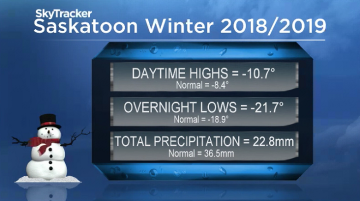
Temperatures ended up trending 2.4 degrees colder than normal throughout winter 2018-19 with 62 per cent of the normal precipitation recorded at the airport.
December and January were so dry with less than half the normal precipitation that a wetter than normal February wasn’t enough to push the numbers above normal.
Saskatoon forecast
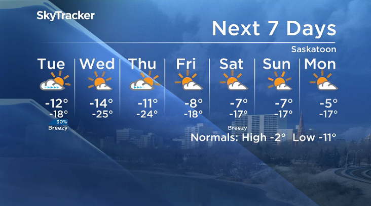
Monday
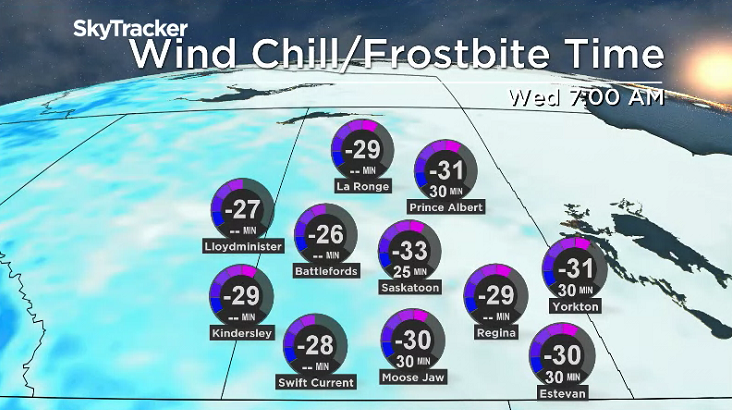
-31 is what it felt like to kickoff the first week of March with wind chill as temperatures slid back to -18 degrees overnight, making it the mildest morning so far this month.
A strong northwesterly wind with sustained speeds pushing 46 km/h and gusts upwards of 60 km/h kicked in during the morning as the mercury climbed up to -15 before noon under mostly cloudy skies.
Clouds stick around into the afternoon with a chance of a few flurries as winds remain strong and conditions continue to warm up a few degrees further.
Monday night
Skies start to clear Monday night as winds start to ease and temperatures drop down to around -18 C overnight.
Tuesday
-28 is what it’ll feel like with wind chill Tuesday as you’re heading out the door under a mix of sun and cloud to start what will be the new mildest morning of the month so far.
After some midday sunny breaks, another round of clouds with a slight chance of flurries will filter in during the afternoon with w breezy northwesterly wind as temperatures warm up to around -12.

Wednesday-Friday
High pressure returns the region to mostly sunny skies on Wednesday with a chilly morning low of -25 with wind chills in the mid -30s before a daytime high in the mid-minus teens is reached.
Clouds return on Thursday and linger at times on Friday as daytime highs pop up from around -11 on Thursday into minus single digits for the first time this March on Friday.


Weekend outlook
A mix of sun and cloud is slated for the second weekend of the month with daytime highs expected to stay in minus single digits both Saturday and Sunday.
The March 4 Your Saskatchewan photo was taken by Lindsay Briggs near Saskatoon:

Saskatoon weather outlook is your source for Saskatoon’s most accurate forecast and is your one stop shop for all things weather for central and northern Saskatchewan with comprehensive, in depth analysis that you can only find here.
For weather on the go download the Global News SkyTracker Weather App for iPhone, iPad or Android.
Comments