
After a warmer than normal November with temperatures trending a nearly 2 degrees above average, the first week of December will transition to a much cooler note.

November is the final month of meteorological fall wrapped up with 29.6 millimetres of precipitation reported at the Kelowna Airport, which is 81% of the normal amount typically received during the month.

The entire season of fall ended up seeing 95% of the normal precipitation with temperatures trending almost a degree warmer than normal, which is fairly significant when averaging over 90 days of data.
The first weekend of December kicked off with another wave of warmer than normal air, with daytime highs in mid-positive single digits, when normally they would sit around the freezing mark.
The above average trend kicked off the work week with the mercury dipping back to -2 Monday morning under cloudy skies before warming above freezing before noon.
Sunny breaks moved in midday, sticking around at times through the afternoon with an afternoon high in mid-single digits once again.
The chance comes mid-week though as an arctic high pressure system brings in polar air that will knock temperatures into mid-minus single digits Monday and Tuesday nights.


Clouds will remain in the valley during the morning hours thanks to an inversion with warm air aloft and sinking cool air at night that mixes with warm moist air over the lake, causing quick saturation and cloud formation.
High pressure will help clear out those clouds for the next few afternoons to bring back the sun, but on Tuesday, temperatures will only make it up to the freezing mark and highs will stay a few degrees below for the rest of the week.
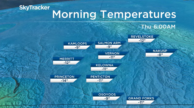
With the sub-freezing daytime highs will come the first minus double digit morning lows of the season early Thursday and Friday.
Relief from the cold week is on the way for the weekend with temperatures pushing back to and potentially even above freezing during the day as an upper ridge tries to build back in.

For weather on the go download the Global News SkyTracker Weather App for iPhone, iPad or Android.
- Life in the forest: How Stanley Park’s longest resident survived a changing landscape
- ‘Love at first sight’: Snow leopard at Toronto Zoo pregnant for 1st time
- Buzz kill? Gen Z less interested in coffee than older Canadians, survey shows
- Carbon rebate labelling in bank deposits fuelling confusion, minister says
Comments