

The days are getting darker and colder, and it’s only a matter of time until winter officially arrives. So will Canadians be piled under mountains of snow or enjoying mild winter days? Well, it depends where you are.

After a beautiful summer across the country, fall turned cold quickly and it’s on tap to be one of the coldest in Canada in decades. The good news is that extremes in October and November are not necessarily a sign of the winter ahead.
Let me explain.
The jet stream is something we watch closely, especially in the winter. As the season changes from fall to winter, the winds in the jet stream increase, which in turn changes the alignment and weather patterns. When the jet is farther north than usual or more zonal (west to east across Canada) then look for warm and wet conditions. When it’s farther south, weaker, or more amplified than normal, you look for cold to take hold across parts of the country.

This year a weak El Nino (warm water in the Pacific), the warm blob south of Alaska and blocking over the Arctic (warm air over the pole that displaces the cold south) are all things I’m watching closely. Here’s a detailed look at what to expect across the country.

Atlantic Canada
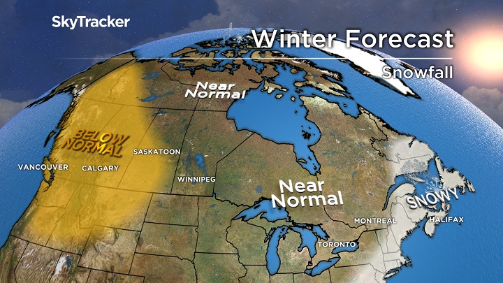
Warm water off the East Coast and a persistent trough around the Great Lakes favours an active storm track in Atlantic Canada. There will be plenty of cold air feeding in from the northwest to make more of these snow producers versus rain or a mix. Above-normal snowfall is expected thanks to more nor’easters like we’ve seen this fall.
WATCH: Snow and hurricane-force winds pelt Newfoundland during winter storm

Ontario and Quebec
Winter is off to the races in many areas of Ontario and Quebec with several ski hills recording their earlier opening date in years. While I do expect it to warm up slightly at the end of November and early December, the pattern favours more snow and cold arriving well before the holidays. Can you say WHITE CHRISTMAS? Later this winter, I’m concerned for a similar setup to the cold winters of 2014 and 2015 where the Polar Vortex made an appearance.

Late January or February could turn frigid before a milder March. Big swings also seem to be the new winter normal and that will be the case again this year. Bad news for cities dealing with the never-ending pothole problem.

Prairie provinces


It’s been a weird fall in the Prairies, extreme cold and snow in late September and October turned to a milder pattern in late fall. These big swings will continue this winter and the farther west you are, the better chance of above-normal temperatures. A big ridge will anchor itself off the West Coast but often spill into Alberta and Saskatchewan, keeping the area milder and dry. A typical winter is expected further east in Manitoba with near-normal cold and snow.
B.C.
With the upcoming El Nino, the subtropical jet stream will be stronger than normal and bring needed rain and snow to California. This combined with a warm pool of water south of Alaska will lead to more high pressure and less cold and snow than normal for the mountains of B.C. The good news for skiers is that when the ridge occasionally breaks down, the storms may line up bringing heavy snow totals in a short amount of time. In other words, lots of POW!
WATCH: Family shares first-ever experience with snow after arriving in Canada

Yukon, N.W.T. and Nunavut
A cold fall has helped restore sea ice to the region but don’t expect these below-normal temperatures to last. Arctic blocking will be on the increase this winter starting near Greenland but spreading west with time. Above-normal temperatures and near-normal snowfall is expected.

WATCH: Largest virtual snowball fight kicks off in B.C.

Comments