
Get ready to say goodbye to warmth and sunny skies and hello to rain and even some high-elevation snow.

The wonderful, warm finish to September will come to a bitter end, thanks to the breaking down of a ‘Rex Block,’ which is a blocking pattern in the atmosphere that has been protecting southern B.C. from any significant systems all week.
The week, filled with high clouds, temperatures in the upper teens or low 20s and beautiful sunrises and sunsets, will continue on Friday under mostly sunny skies and an afternoon high in the upper teens. However, this won’t last much longer.
As the Rex Block bends and stretches apart, a system and upper trough will sneak in and build in clouds on Saturday with a chance of rain late in the day.
Daytime highs will drop back a bit into the mid-teens on Saturday before falling even further into the low teens on Sunday.
The reason for the fall in temperatures will largely be due to rain rolling through the valley during the day, which will fall as snow at higher elevations.
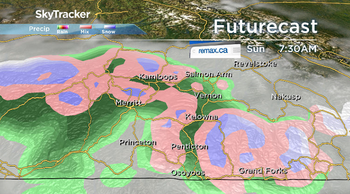
The rain/snow line is anticipated to be as low as 1,500 metres on Sunday, so be sure that you are equipped with appropriate winter or all-season tires before heading onto any mountain highways.


M-S (mud and snow) or mountain snowflake tires with a minimum 3.5 millimetre tread will be required come October 1st on Monday for all mountain highways, including the Okanagan Connector.
Rain will start to ease on Monday with some lingering clouds as daytime highs settle into the mid-teens heading into the first week of October with a bit more sunshine by mid-week.

For weather on the go download the Global News SkyTracker Weather App for iPhone, iPad or Android.
- Budget 2024 failed to spark ‘political reboot’ for Liberals, polling suggests
- Train goes up in flames while rolling through London, Ont. Here’s what we know
- Peel police chief met Sri Lankan officer a court says ‘participated’ in torture
- Wrong remains sent to ‘exhausted’ Canadian family after death on Cuba vacation
Comments