

Spring may be upon us — it officially arrives Tuesday — but some Canadians will need to wait a while longer for warmer weather to arrive.

I like to call this transition season between winter and spring “sprinter,” and for most of Canada, the weather can range from sunshine, BBQs and short sleeves to cold arctic winds, thumping snow storms and frustration.
Unfortunately for much of Canada, the latter will be truer than the former.
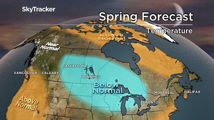
After a winter of extremes, influenced by a weak La Nina, spring will be off to a slow start as blocking over the Arctic pushes cold air further south than usual through the month of April. Not only will temperatures average several degrees below normal but an active storm track will continue and that means more accumulating snow for just about every Canadian city east of Vancouver.
WATCH: Vancouver Aquarium otters fool around with snowballs

There is some good news in this spring forecast: Once past April, temperatures should rebound and the second half of spring could quickly flip, bringing an early taste of summer weather across the country. Let’s get to the details as we go region by region across Canada.
British Columbia
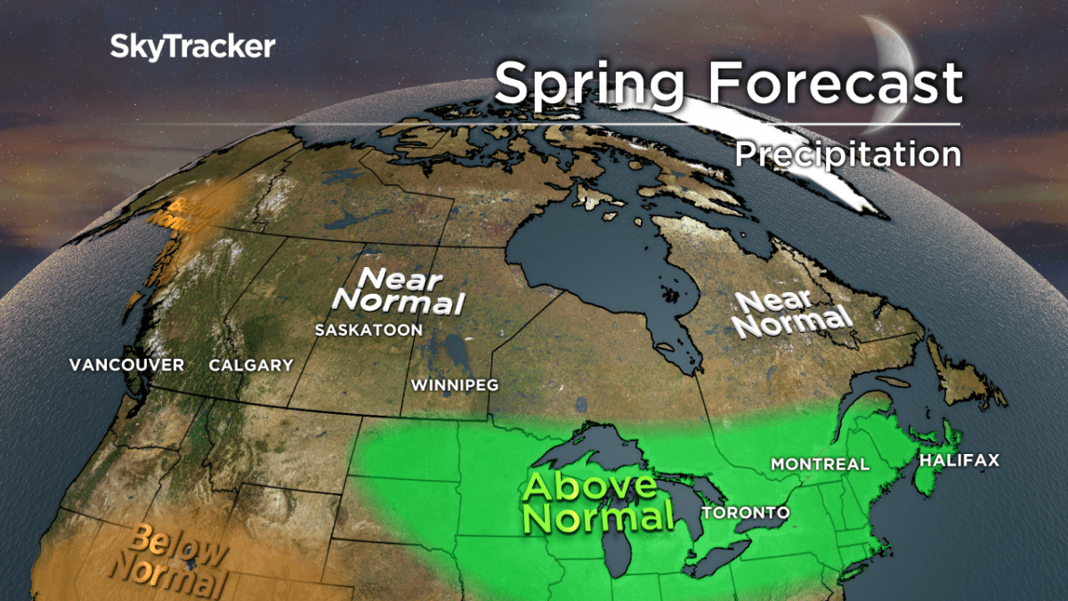
An active storm track will keep most of B.C. cooler than normal through the first several weeks of spring. Heavy mountain snow and valley rain will be welcome news for skiers but also hopefully prevent a serious fire season this summer.
It’s one of those “take the moisture while you can get it” scenarios as computer models are hinting at a drier and milder pattern in May and June and potentially a hot and dry summer.
WATCH: Metro Vancouver begins digging out of heavy snowfall

Prairies
Winter weather will linger through April this year with several chances of significant snow, especially in Alberta. Calgarians have just lived through the wettest winter in 46 years when you combine all the melted snow (over 1 metre) and rainfall.
On the other hand, much of Saskatchewan and Manitoba have below-normal snowpack, so the wet and cool spring will be welcome news for farmers. A significant flood season is not expected this year.


Ontario and Quebec
The ups and downs of this past winter were enough to give you whiplash: the second half of February felt like April, while March has felt like February. Colder-than-normal temperatures will be common through the first half of spring with the potential for at least another couple snow storms.
A wetter-than-normal spring could lead to significant flooding across eastern Ontario and Quebec where the snowpack has built back up through the month of March. Still, we do not expect a repeat of the record 2017 spring floods of Lake Ontario and the Ottawa River.
A sudden flip to above-normal temperatures is expected in early to mid-May.
Atlantic Canada
After mild and benign weather for most of winter, a recent onslaught of powerful nor’easters have left even hearty Maritimers battered and fatigued. The parade of intense coastal storms may be ending but colder-than-normal temperatures and above-normal snowfall will last through April.
A deep snowpack is developing in New Brunswick and this could lead to another significant flood season depending on how quickly the snow melts this spring.
WATCH: Maritimes brace for intense winter storm, hurricane-force winds expected

Yukon, NWT and Nunavut
The winter was a mild one across the Arctic and with continued blocking ridges, temperatures this spring will remain above seasonal.
The further north you go, the warmer it will be compared to average. This will also lead to above-normal snowfall in many locations through the first half of spring.
Share your spring photos and videos
When you do spot a sign that spring has sprung, post it on social media with the hashtag #GlobalSignsofSpring. We’ll be posting some springlike photos and videos to our @GlobalNews Instagram account.
Comments