
Environment Canada has issued a warning saying that hurricane-force winds are expected for an area just off the coast of Vancouver Island, while storm warnings are in effect closer to land.

Winds could blow at up to 120 km/h in what’s known as the “Explorer — southeastern half” region, which is off Vancouver Island.
Coverage of wind on Globalnews.ca/bc:


The weather forecaster expects winds to diminish to speeds of anywhere between 74 km/h and 92 km/h on Thursday morning before they dissipate even further in the afternoon.
Waves could reach heights of up to 43 feet in the southern part of the Explorer region before dissipating on Thursday to anywhere between 22 and 32 feet.
The winds come with a low-pressure system that’s expected to move over offshore waters on Wednesday night and stay there on Thursday.
READ MORE: Vancouver could see winds as strong as 90 km/h on Monday
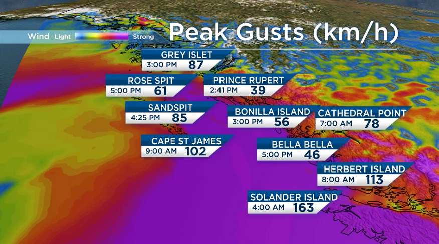
Winds reached speeds of up to 163 km/h on Solander Island, just off of Vancouver Island’s west coast, at 4 a.m. on Wednesday morning.
That’s the wind speed of a Category 2 hurricane.
“The winds have been strong all day,” said Global BC senior meteorologist Kristi Gordon.
“They’ll continue to be through tomorrow.”
Closer to Vancouver Island’s shores, a storm warning is in effect with winds of anywhere between 74 km/h and 93 km/h are expected in the north, though they could reach as high as 111 km/h near the headlands.
Winds are forecast to taper off to 56 km/h to 74 km/h on Thursday afternoon. Meanwhile, waves could reach as high as 32 feet.


Meanwhile in the south, winds could reach a range of 65 km/h and 83 km/h, though they could reach as high as 93 km/h northwest of Estevan Point into Thursday morning, with waves hitting as much as 36 feet.
Those winds are forecast to taper off to a top speed of about 65 km/h on Thursday night.
But the waters off Vancouver Island aren’t the only ones where high winds and waves are expected into Thursday.
Waves reaching as high as 50 feet are forecast for the waters off Washington state and Oregon, according to KIRO 7 chief meteorologist Morgan Palmer.
He said high swells along the coast could lead to “crashing waves, beach erosion and some coastal flooding.”
Comments