


Extreme Cold Warning

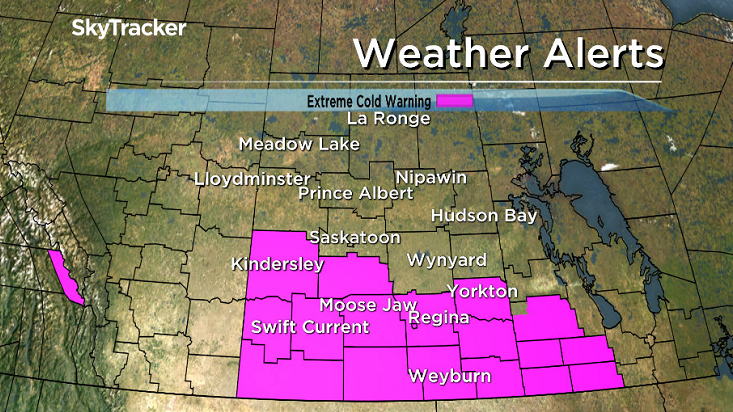
Environment Canada has issued an extreme cold warning just south of Saskatoon including the Hanley, Outlook, Biggar, Rosetown, Regina, Swift Current and Yorkton areas. A period of very cold wind chills is expected Tuesday night.
A ridge of high pressure over the southern Prairies will keep skies clear tonight and allow temperatures to drop below -30 degrees in this region. A combination of west winds of up to 20 km/h will yield overnight wind chills below -40.
Wind chills will moderate through the day on Wednesday, however extreme cold warnings may need to be reissued again Wednesday night.
Saskatoon may also see extreme cold warning criteria met tonight with -40 wind chills, however the city is not included in the warning.
Extreme cold wind chills in the -40s started the day in Saskatoon as the clouds and light snow cleared out a little earlier than anticipated overnight.
Saskatoon had a wind chill of -41 at 8 a.m. CT, while the wind chill was -44 in Leader and -42 in Elbow.
Frost bite can occur on exposed skin within 10 minutes at those values.

The extreme cold forced a number of school bus cancellations in the Saskatoon area.
READ MORE: Cold weather forces school bus cancellations in the Saskatoon area
For the latest weather conditions download the Global News Skytracker weather app for iPhone, iPad or Android.
By noon Saskatoon had warmed all the way up to -22 with wind chills around -31.
The sunshine that started the day is expected to continue into the afternoon as the mercury rises up a bit further, likely popping into the minus teens with wind chill values around -30 all day.
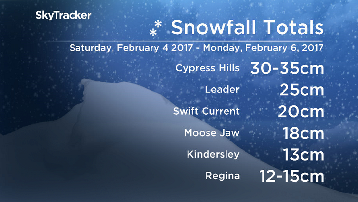
The numbers are in for the significant snowfall that hit parts of southern Saskatchewan.
Values were not as impressive as the metre of snow seen in southern Alberta, but totals of up to 35 centimetres were seen in parts of our province.
Tonight
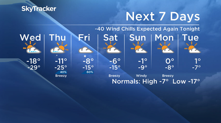
Extreme cold warning criteria is likely to be met tonight as clear skies continue through the evening, allowing temperatures to fall toward -30 and wind chills to dip into the -40s.
Wednesday
Some clouds associated with a trough are expected to move in overnight, moderating conditions a bit, which may warm us slightly above the extreme -40 wind chill threshold by morning.
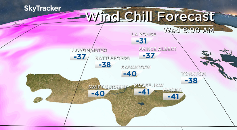


Partly to mostly cloudy skies are expected into the middle of the day, helping warm us up a degree or so into the minus teens for an afternoon high before clouds clear out later on.
Thursday-Friday
Thursday will start out under sunny skies with cooler temperatures and wind chill values pushing into the low -30s before cloud cover builds in during the day.
A low pressure system developing in Alberta will help push in milder conditions, with the mercury rising up right through the minus teens to around -11 with a chance of snow into the evening.
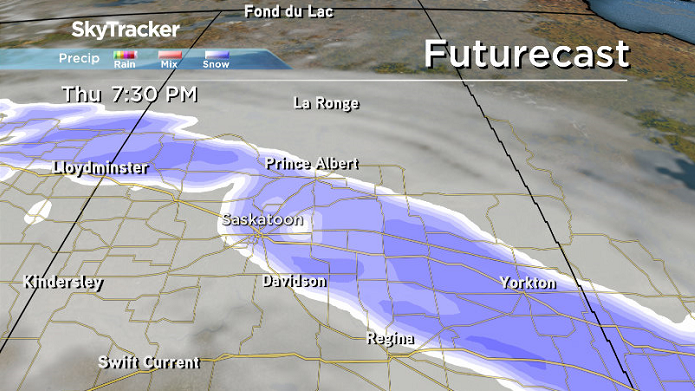
That system will slide through on Friday, bringing with it the clouds and a good chance of snow during the day as we warm even further into minus single digits for a daytime high.
Weekend Outlook
Saturday will likely start out with some clouds that will then clear out during the day as temperatures rise into mid-minus single digits.
We get into some more sunshine for Sunday with an afternoon high around or possibly even just above the freezing mark as a moderate westerly wind kicks in.
This Your Saskatchewan photo was taken by Trevor Altman in Creighton:

Saskatoon weather outlook is your source for Saskatoon’s most accurate forecast and is your one stop shop for all things weather for central and northern Saskatchewan with comprehensive, in depth analysis that you can only find here.
Comments