

After a soggy start to November, a massive upper ridge takes hold bringing back the sunshine and a big warm up!

October 2016
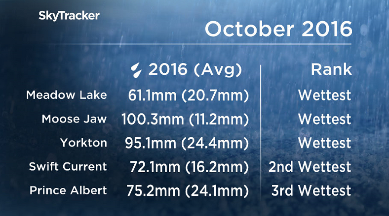
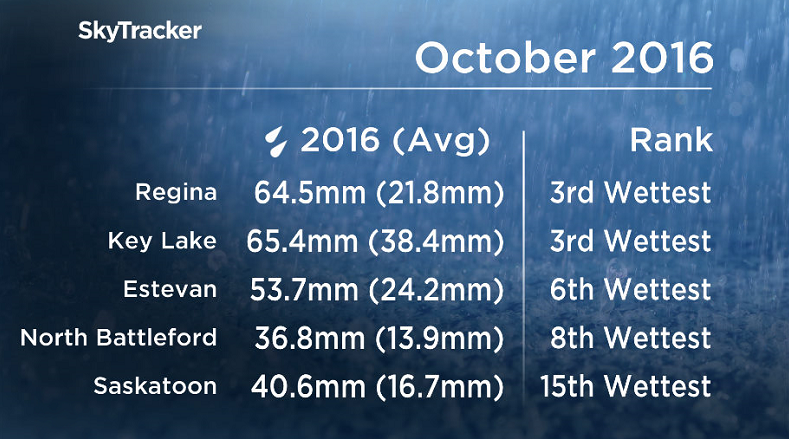
October 2016 was the wettest October ever recorded in parts of Saskatchewan, including Meadow Lake, Yorkton and Moose Jaw with Prince Albert reporting the 3rd wettest.
After coming off of a warmer and drier than normal September, the month of October was completely the opposite for Saskatoon!
October 2016 was much colder and wetter than normal in the city with temperatures an average of two degrees cooler than normal and over two times our normal precipitation.
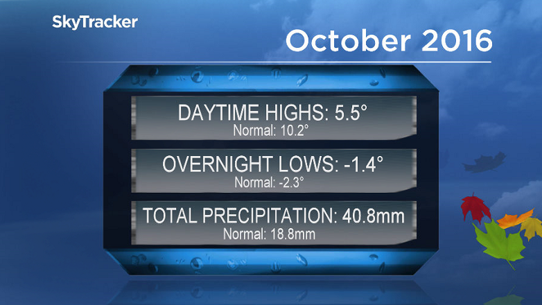
When you break the numbers down, the city saw 40.8 millimetres of melted snow, rain and other forms of precipitation throughout the month when normally we would see 18.8 millimetres.
Temperatures were particularly interesting as overnight lows actually trended almost one degree warmer than normal during the month, but it was countered by overnight lows that were nearly five degrees colder than normal!

It was also a very cloudy month for Saskatoon with 12 whole days with absolutely no sunshine!
Overall the city saw only 61.1 hours of bright sunshine throughout October, that’s less than half the normal number of 156.1 hours.
Saskatoon Forecast
Tuesday
After a mostly cloudy Halloween, we’ve started the first day of November on a similar note, but this time we’re adding in precipitation!
Rain started in Saskatoon late Tuesday morning as a low pressure system and cold front slid through, kicking up northerly winds to around 20 gusting upwards of 35 km/h at times.
Further north the rain switched over to snow in the Prince Albert area with the precipitation in both regions moving out of the area in the afternoon.
Temperatures started out promising, up to around 4 C by 10 a.m., but the rain kicked the mercury back to just a degree above the freezing mark by noon.
Once the rain tapers off we may see it rebound up a few degrees under mostly cloudy skies to end the day.


Wednesday
-8 is what it’ll feel like with wind chill when you wake up Wednesday morning pending the clear breaks occurring overnight as we do expect them to.

The cloud cover will return just in time for the morning and the majority of the day before clearing out into the evening.
Temperatures should recover during the day up to a high in mid-single digits as a southerly wind kicks in.
Thursday-Friday
A massive upper ridge of high pressure takes hold of central Saskatchewan to finish off the first week of November, pushing in the heat and the sunshine.

As such, mostly sunny skies are expected both Thursday and Friday with daytime highs pushing into low double digits!
Weekend Outlook
The ridge looks like it’ll hold strong right through the weekend with loads of sunshine expected and afternoon temperatures topping out in the low teens!
This Your Saskatchewan photo was taken by Tyra Borstmayer near Bremen:

Saskatoon weather outlook is your one stop shop for all things weather for Saskatoon, central and northern Saskatchewan with a comprehensive look at your local forecast that you can only find here.
Comments