

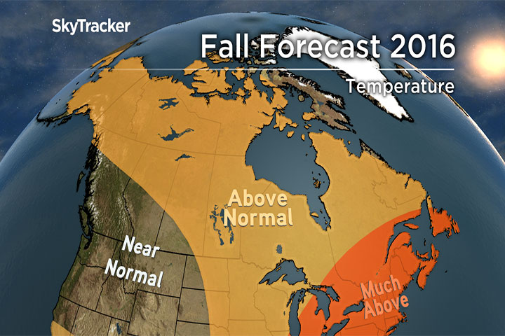
With the kids back at school, the nights getting longer, and leaves already starting to change colour in spots, it’s time to let go of summer and start thinking about the fall season. Luckily for much of Canada, this transition should be an easy one with above-normal temperatures dominating the pattern into early November. This is not to say there won’t be cold shots bringing frost and potentially early snow, but overall the warm days will far outnumber the cool ones.

READ MORE: ‘There isn’t any connection to El Nino’—Alberta suffers through damp, soggy summer
The global pattern is changing as the effects of last winter’s “super El Niño” wears off. In the Pacific, the El Niño has been replaced by neutral to weak La Niña conditions. This change will have a limited effect on our fall but could make for an interesting winter season. That is a discussion for another time. Here’s a look at what to expect this fall from east to west across the country.
Atlantic Canada
A persistent ridge off the U.S. east coast will maintain a southern flow of warm air into the month of October. Temperatures could be as much as 1 to 3 C above normal this fall.
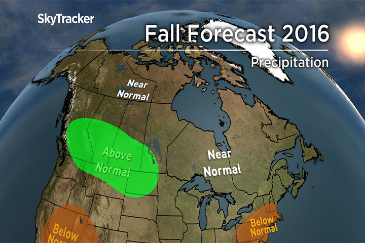
Drought conditions developed over the summer across much of Nova Scotia, and several days of soaking rain are needed to alleviate the situation. This may very well occur in late September or October as the Atlantic hurricane season heats up again. With ocean temperatures well above normal, any one of these tropical storms or hurricanes has the potential to maintain strength entering Canadian waters. It may well be a case of too much of a good thing where rain is needed but flooding and damaging winds are not. Stay tuned…
Ontario and Quebec
A severe drought remains in place for parts of southern and eastern Ontario. Recent rains have helped, but more is needed. With average precipitation expected this fall, the situation may not improve much, but also won’t worsen. The lack of summer rain will, however, have an effect on the fall foliage season with early leaf loss and less vivid colours expected this year.
Above normal temperatures will continue through October and potentially November across Quebec and Ontario. This may be another very late start to winter as warm water off the east coast favours ridging.


Prairie Provinces
Summer got off to a warm start in the Prairies but fizzled down the stretch with a cool, wet pattern dominating late July and August. Calgary ended up with the wettest July in almost 90 years.
For the fall, seasonal temperatures and normal precipitation are expected through September, but the longer range computer models are trending warmer and wetter late in October and November. As is often the case, watch for an early taste of winter even if the overall pattern is warm.
West Coast
Temperatures across British Columbia will start off below seasonal, but as the jet stream intensifies later this fall, mild and moist air will flow in from a big blob of warm water sitting off the west coast. This blob weakened last winter but has since reemerged, and could have a big effect on the winter ahead. With a rainy November expected, precipitation will average above-normal across southern areas.
For a detailed look at what to expect in your area download our free SkyTracker weather app.
Comments