
One-hundred millimetres of rain has fallen in parts of Saskatchewan with states of emergency declared.

READ MORE: States of emergency in effect for Saskatchewan communities
Rainfall Warning
A rainfall warning has been ended for Saskatoon, but remains in place for parts of central, southern and eastern Saskatchewan for 70 to 100 millimetres of heavy rain expected by Wednesday morning.
Environment Canada says locally higher amounts are also possible with some embedded convection.
As of 8 a.m. parts of the province had already seen nearly 100 millimetres of rain fall.
Saskatoon saw 23.6 millimetres as of mid-morning.
Multiple communities have declared states of emergency due to excessive flooding.
The culprit for the heavy rain is a deepening low pressure system in North Dakota that is stalling over Saskatchewan.

Get daily National news
Elsewhere across the south, general amounts of 40 to 50 mm are expected before the entire system moves off into Manitoba early Wednesday.
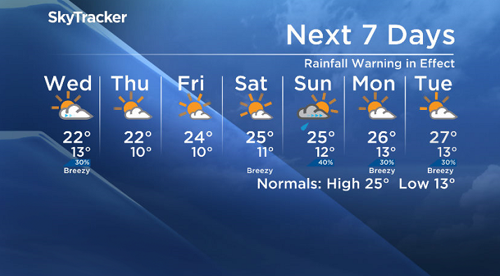
Saskatoon Forecast
Today
After a rainy morning the wet weather is expected to stick around for the rest of the day.
Winds are also fairly breezy in the 30 to 40 km/h range with gusts upwards of 50 km/h possible this afternoon.
A further 10 millimetres or so is possible through the rest of the day in Saskatoon.
The rain has put a damper on temperatures, with the mercury sitting in the 15 to 16 degree range all night, through the morning into the early afternoon with a daytime high only expected to be a degree or so warmer.


Tonight
The rain will ease off this evening, but the clouds will stick around overnight as we drop back to around 13 degrees.
Wednesday
- Trump doubles down after U.S. Supreme Court strikes down global tariffs
- Danielle Smith promises Alberta referendum over immigration, Constitution changes
- Canadians say U.S. no longer an ally, is bigger threat than Russia: poll
- Porter flight from Edmonton loses traction, slides off taxiway at Hamilton airport


Tomorrow will start off under mostly cloudy skies before we get some clearing and see a return to some sunshine in the afternoon.
We’re expecting to see temperatures return back to the low 20s in the afternoon as well with much lighter winds around 30 to 40 km/h from the northwest.
Thursday-Friday
The rest of the work week looks much calmer under partly to mostly sunny skies with daytime highs pushing back up from the low 20s on Thursday into the mid-20s on Friday.
Weekend Outlook
Mostly sunny skies are expected on Saturday as a bit of ridging occurs in the upper atmosphere followed by a sunny start to Sunday with clouds building back in through the day and a chance of late day showers or thunderstorms.
Both days of the weekend it looks like daytime highs should top out in the mid-20s.
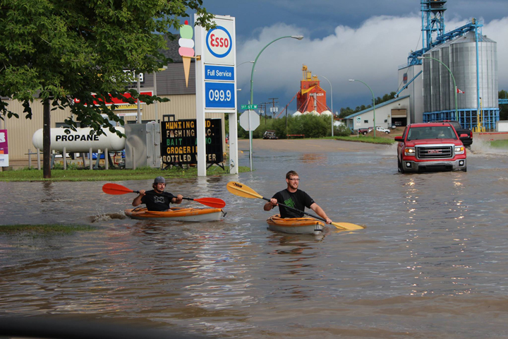
This Your Saskatchewan photo of the flooding in Carrot River was taken by Shelly White:
Saskatoon weather outlook is your one stop shop for all things weather for Saskatoon, central and northern Saskatchewan with a comprehensive, detailed look at your local forecast that you can only find here.
Comments
Want to discuss? Please read our Commenting Policy first.