
WINNIPEG — While Winnipeg and other parts of southern Manitoba are likely to break temperature records Monday, don’t get used to it.

Winnipeg appears set to break the record high of 11.4 C, which dates back to 1981.
But a reality check is looming and will begin to set in before the day is over.
A low pressure system is moving through the Prairies and will bring rain and snow to parts of Manitoba.
At this point, Environment Canada is calling for mostly rain for Winnipeg that will begin late Monday with a risk of a thunderstorm before morning.
Tuesday 10-15 millimetres of rain is in the forecast with a daytime high of 7 C.
East-central Saskatchewan is looking at snow amounts that could total up to 30 cm by Wednesday morning as colder air begins the push in.
That system will begin to draw in colder air for us here in Manitoba by Wednesday and that rain could turn to snow.
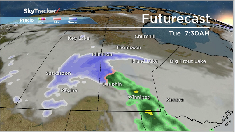


Western Manitoba along the Saskatchewan border appears to be the region that will be affected most by snowfall.
- Life in the forest: How Stanley Park’s longest resident survived a changing landscape
- ‘Love at first sight’: Snow leopard at Toronto Zoo pregnant for 1st time
- Buzz kill? Gen Z less interested in coffee than older Canadians, survey shows
- Carbon rebate labelling in bank deposits fuelling confusion, minister says
Amounts for that area could total 10-15 cm.
How much snow we’ll see in the city will depend on temperatures.
Wednesday night we are looking at overnight lows in the -3 C range and progressively getting colder the rest of the week.
After that, it looks like the second half of March will be more or less seasonal temperatures.
The average high is -1 C while the overnight low is a chilly -11 C.
Global News will have the latest information on the storm as it continues to make its way toward Manitoba. Changes to this forecast are possible over the next 24 hours.
Comments