
SASKATOON – Tuesday saw Saskatchewan sizzling in historic heat with numerous temperature records broken across the province. Saskatoon hit 17.5 degrees Celsius at 4 p.m., toppling the old March 31 high temperature record of 16.2 from 1991.

Saskatonians were seen outside enjoying the weather across the city, including one watercraft enthusiast on the South Saskatchewan River.
The mild finish to March is short lived though.
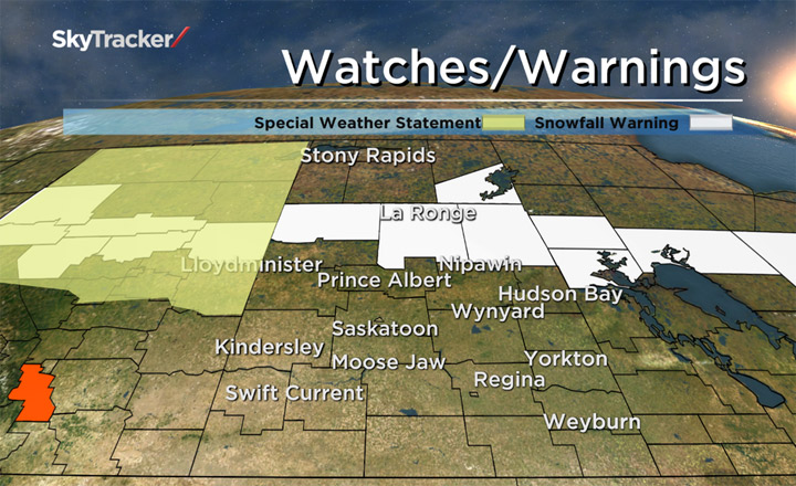
Just as historic high temperatures were being set Tuesday afternoon, a slew of snowfall warnings were issued by Environment Canada in Saskatchewan.
Ten to 15 centimetres of snow is expected by Wednesday night in the Buffalo Narrows, La Ronge, Prince Albert National Park, Pelican Narrows and Southend areas as a low pressure system moves across the province. Environment Canada says the heaviest snow is expected to fall between Buffalo Narrows and Pelican Narrows.
In addition, a special weather statement has been issued in Lloydminster for 10 to 15 centimetres of snow and strong winds Tuesday night and Wednesday.
The agency says Lloydminster is in the main axis of the heaviest snow with in excess of 15 centimetres possible for the region.
A developing system in Alberta that will be responsible first for the warm push of air Tuesday will sweep through Wednesday with a cold front knocking temperatures back to below seasonal.
As it comes crashing through, it will first bring rain during the day Wednesday, which will then turn to snow Wednesday night into Thursday morning.


Snowfall isn’t expected to amount to any significant accumulations at this point, however it will make for slick travel conditions early Thursday morning as temperatures dip below freezing by a few degrees.
Heading into the Easter long weekend, temperatures are expected to settle slightly below seasonal with lots of freeze/thaw. At this point, daytime highs are expected to be in the low to mid single digits and overnight lows in minus single digits with no significant precipitation events.
For weather on the go download the Global News Skytracker weather app for iPhone, iPad or Android.
Snowfall warnings ISSUED for:
- Île à la Crosse – Buffalo Narrows – Beauval
- La Ronge – Prince Albert Nat. Park – Narrow Hills Prov. Park
- Pelican Narrows – Cumberland House – Creighton
- Southend – Brabant Lake – Kinoosao
Special weather statement ISSUED for:
- Lloydminster
Comments