
For most Canadians, just the thought of another long, cold, snowy winter brings a chill to the entire body and rightfully so.

READ MORE: Weather challenge: Who had the worst winter in Canada?
Last winter was well below normal from Alberta to Quebec, and snowstorms were plentiful from coast to coast. It was Winnipeg’s coldest winter in more than 110 years with frozen ground being reported by construction workers well into June.
In Windsor, Ontario, the city saw its snowiest winter on record with 250 cm of snow. Several Nor’easters rocked Atlantic Canada with heavy wet snow and near hurricane-force winds.
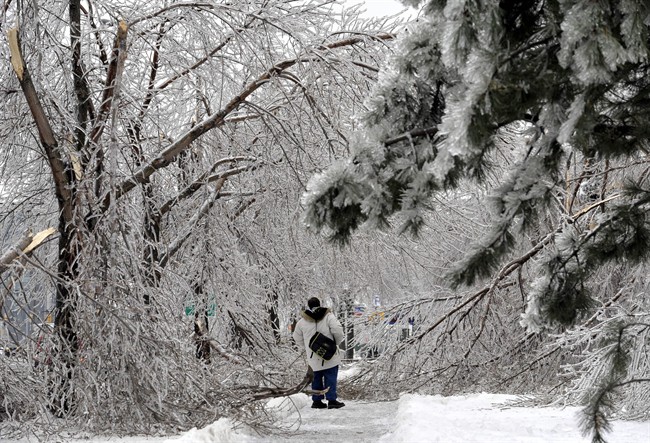
And who could forget the historic ice storm of December 2013 where a weekend of freezing rain caused extensive damage to trees in the Greater Toronto Area, and left thousands across Ontario and Quebec without power for days?

The cold was relentless and caused the Great Lakes to almost completely freeze over. Ice coverage was the highest since the brutally cold and snowy winters of the lake 1970s.

The good news about the winter ahead is that it’s not going to be as severe as last year.
The bad news is that for most of southern Canada, winter will still bring plenty of cold and snow. As of writing this, Arctic air stretches across most of North America with snow flying as far south as Arkansas. This is incredible considering it’s only the middle of November.
Will we see the polar vortex again this winter?
The answer is: yes. The polar vortex visits Canada almost every year and brings dangerously cold air south from the far north. Last winter this vortex set up shop around the Great Lakes in January and, while this could happen again, it’s more likely that it comes and goes quickly.
Will we see another major ice storm?
Ice storms are very hard to predict days in advance let alone weeks or months in advance. A weak El Nino is setting up which favours a stronger southern storm track with more moisture. This could lead to more snow but also a higher than normal chance of ice storms in Ontario and Quebec as warm meets cold.
How will El Nino affect the weather in Canada this winter?
El Nino is a warming of the water in the equatorial Pacific that affects the jet stream and therefore temperature and moisture patterns around the globe.
This winter, computer models are forecasting a weak El Nino which should lead to a stronger southern jet stream and an active storm track near the east coast. A weak El Nino does not control winter weather like super El Ninos, such as the one in 1998 that brought us the historic ice storm.
READ MORE: El Nino – What it is and why it matters


- Warm water off the west coast was there last winter and remains in place. This favours a ridge of high pressure and blocking out west.
- A weak El Nino is setting up for the winter season. It’s biased more towards the central Pacific, which will make for an active southern jet stream
- Warm water off the east coast will also build a strong ridge and concentrate the storm track near the east coast. These storms will bomb out as they hit the warm water delivering snow to Atlantic Canada.
The Big Picture
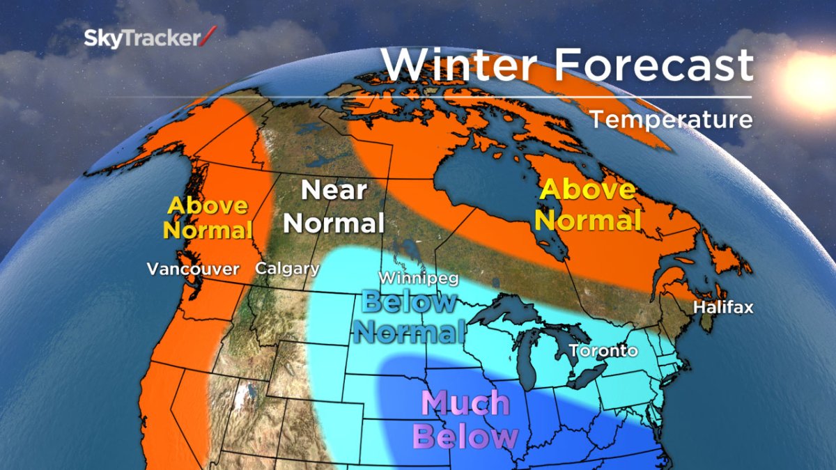
Above normal temperatures are expected across most of northern Canada as blocking takes hold and lasts through much of the winter. This blocking could extend far enough south at times to send the core of the cold further south than last winter. This is great news considering the southern prairies are coming off one of the most brutal winters on record.
Before you get too excited, a colder than normal winter is still forecast from southern Saskatchewan and Manitoba through most of Ontario and southern Quebec. Warm east coast water temperatures and an occasional ridge backing west will lead to a warmer than normal winter for most of Atlantic Canada. Another ridge will flex its muscle along the west coast bringing warmer than normal conditions from California to Alaska including British Columbia and parts of Alberta.
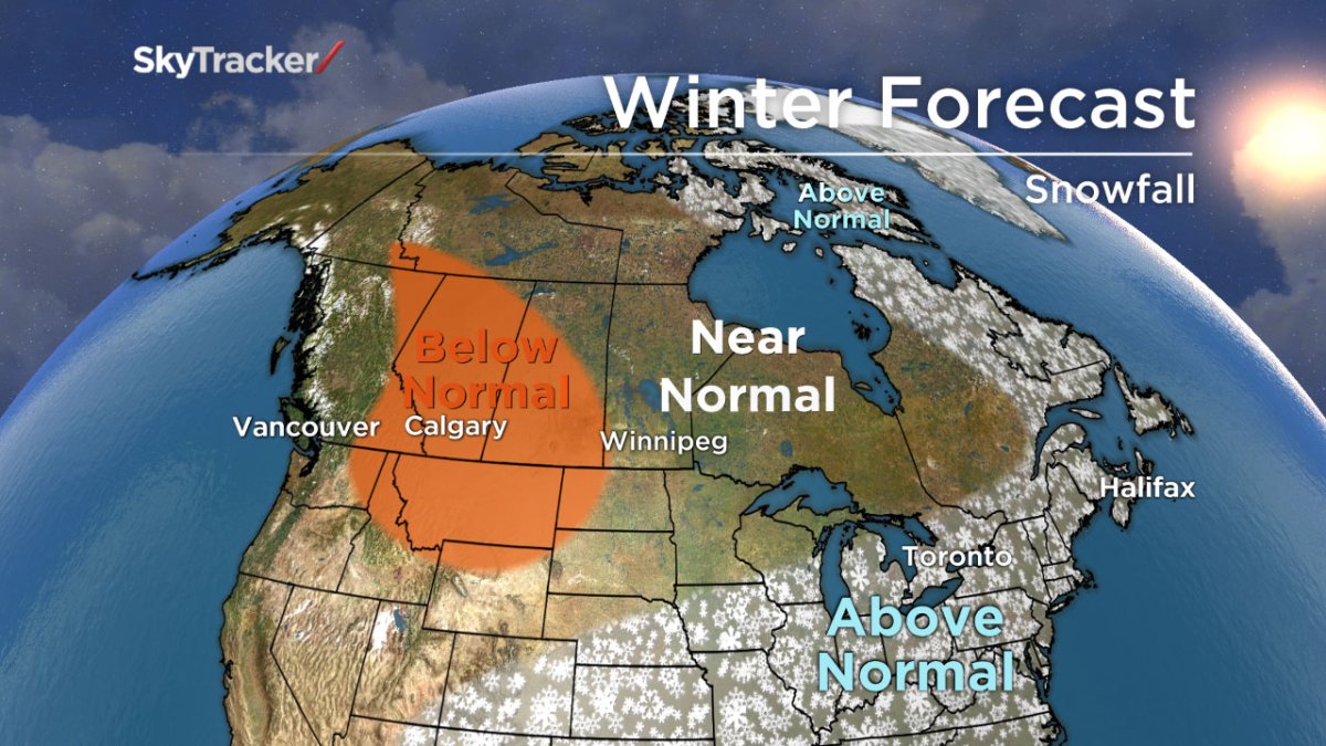
Expect another active storm track with frequent snow storms riding up the Appalachians and bombing off the northeast U.S. coast. This will lead to a swath of above normal snow stretching from the southern U.S. through southern Ontario, Quebec and Atlantic Canada.
Warmer and drier air out west will bring below normal snowfall to Alberta and Saskatchewan.
Winter is getting off to an extremely early start across the country but this is not the main event. Cold will ease, snow will melt later in November and December will actually get off to a warm start before the winter pattern settles in.
Comments