


Our live coverage of this year’s wildfires has now ended. This post will no longer be updated.

B.C. is still dealing with back-to-back record wildfire seasons, with more than 1.349 million hectares burned.
On Sept. 7, the B.C. government ended the province-wide state of emergency, in place since Aug. 15.
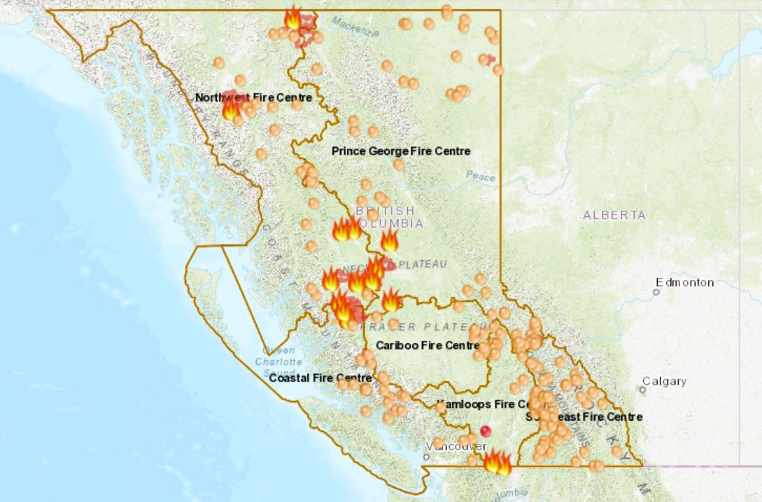
As of Monday, Sept. 17, there are 11 “wildfires of note” burning across B.C.
Wildfires of note are wildfires which are highly visible or which pose a potential threat to public safety.
WATCH: Premier Horgan tours the B.C. central fire zone and meets with evacuees

Two are in the Prince George Fire Centre, eight in the Northwest Fire Centre and one in the Coastal Fire Centre.
There have been more than 2,050 fires reported since April 1, costing the province $450 million.
The BC Wildfire Service has provided a map of where the fires are located (it may not load in high traffic times so you might need to be patient).
The larger icons are the wildfires of note.
FULL COVERAGE: Wildfires burning around B.C.
WATCH: Coverage of wildfires this year on Globalnews.ca

-
![]() BC Wildfires: Second worst season in B.C. history
BC Wildfires: Second worst season in B.C. history -
![]() BC Wildfires: Evacuation orders issued near Pemberton
BC Wildfires: Evacuation orders issued near Pemberton -
![]() BC Wildfires: Tale of two wildfires season
BC Wildfires: Tale of two wildfires season -
![]() Tinder dry conditions sparks aggressive wildfire in Horseshoe Bay
Tinder dry conditions sparks aggressive wildfire in Horseshoe Bay -
![]() Smoke from B.C.wildfires triggers air advisories across Western Canada
Smoke from B.C.wildfires triggers air advisories across Western Canada -
![]() Raging wildfire in Nanaimo Lakes forces evacuations
Raging wildfire in Nanaimo Lakes forces evacuations -
![]() Fire crews getting upper hand in fight against Placer Mountain, Snowy Mountain wildfires
Fire crews getting upper hand in fight against Placer Mountain, Snowy Mountain wildfires -
![]() B.C. wildfire update: Fire crews arrive to British Columbia from New Zealand and Mexico
B.C. wildfire update: Fire crews arrive to British Columbia from New Zealand and Mexico -
![]() Wildfires continue to rage in Western BC
Wildfires continue to rage in Western BC -
![]() Crews try to gain upper hand on Nanaimo Lakes wildfire
Crews try to gain upper hand on Nanaimo Lakes wildfire -
![]() Canadians dealing with raging wildfires and hot weather
Canadians dealing with raging wildfires and hot weather -
![]() BC Wildfire Service issues call for help in firefight
BC Wildfire Service issues call for help in firefight -
![]() Snowy Mountain wildfire more than 6,500 hectares and growing
Snowy Mountain wildfire more than 6,500 hectares and growing -
![]() B.C. Wildfire: Fire danger remains high in the province
B.C. Wildfire: Fire danger remains high in the province -
![]() Wildfires force closure of Highway 93 from Radium Hot Springs to Alberta border
Wildfires force closure of Highway 93 from Radium Hot Springs to Alberta border


The fire was caused by lightning.
Prince George Fire Centre

Chutanli Lake
The 20,813-hectare wildfire is burning approximately 135 kilometres southwest of Prince George.
The fire is also located 11 kilometres northeast of Tatelkuz Lake, 23 kilometres west of Titetown and two to three kilometres west of Batnuni.
It is 95 per cent contained and is considered being held.
The Kluskus FSR is now open to all traffic. However, the Martin Road, Blue Road and Grey Road remain closed due to fire activity.
For details, go to the Cariboo Regional District website and the Regional District of Bulkley-Nechako website.
North of Tezzeron Lake
This wildfire is 10,602 hectares in size and is burning 106 kilometres northwest of Vanderhoof and 13 kilometres south of Inzana Lake.
It is now 40 per cent contained and being held.
Crews are building hand line in the south east of the fire between Dolphin Lake and the Hat Road. Hotspots are being dealt with on the northeast of Dolphin Lake.
The Hat Creek FSR and Hat Creek Connector are closed, and could remain so for the coming weeks. The fire is also burning back towards the Leo Road, however it remains open.
You can find up to date evacuation orders and alerts for the entire region here.
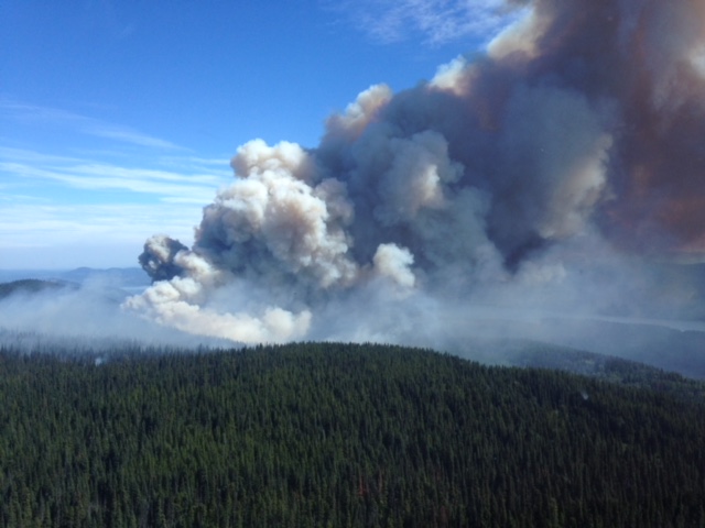
Coastal Fire Centre
Tweedsmuir Complex
Located within Tweedsmuir Park, this complex consists of the Dean River, Ramsey Creek, Tesla Lake and Pondosy Bay fires.
The fire is estimated to be 301,549 hectares in size and is zero per cent contained.
This group of fires has shown little growth for some time. Some sections of the fires in the north Tweedsmuir area are receiving snow, and the latest satellite imaging has not recorded heat for the past four days. This indicates that, while the fires are not out, the activity is so low that it cannot be recorded by this technology.
Portions of Tweedsmuir Park are closed. You can find details through the Regional Distrit of Bulkley-Nechaco, the Cariboo Regional District, and the Central Coast Regional District.
Evacuation alerts and orders are in place for impacted areas. For more information please contact the Regional District of Bulkley-Nechako at www.rdbn.bc.ca, the Cariboo Regional District at www.cariboord.bc.ca and the Central Coast Regional District at www.ccrd-bc.ca

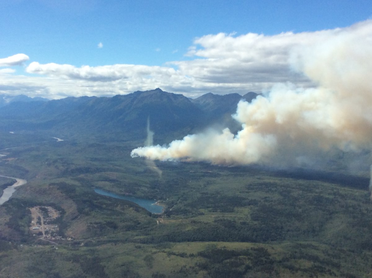
Northwest B.C.

Shovel Lake
This 92,255-hectare wildfire is burning about six kilometres north of the community of Fraser Lake.


There are 87 firefighters on scene, along with four helicopters and four pieces of heavy equipment.
The Shovel Lake Fire is now designated as being held, meaning that with the resources currently committed to the fire, sufficient suppression action has been taken that the fire is not likely to spread beyond existing or predetermined boundaries under the prevailing and forecast conditions.
Crews are working to mop-up and patrol all active flanks, extinguishing hot spots along the fire’s perimeter and working with danger tree specialists and fallers to manage trees that pose a safety risk. Bucketing helicopters will continue to assist crews in cooling down fire behaviour in active spots.
All previous evacuations have been rescinded.
An area restriction for public safety will remain in place for the wildfire near Shovel Lake until at least noon on Sept. 30 or until the order is rescinded.
All orders and alerts are no longer in effect as of Sept. 2 at 12:30 p.m. Resdients are asked to check the Bulkley-Nechako Regional District website.
WATCH: Taking photos and videos of the B.C. wildfires

Verdun Mountain
The Verdun Mountain fire is burning 10 kilometres southwest of Grassy Plains, or approximately 212 kilometres west of Prince George.
It is 47,610 hectares in size but is now 100 per cent contained.
Firefighters continue to patrol properties west of Eakin Settlement Road and patrol the fire perimeter from Dog Creek to Cheslatta Lake. Crews are also patrolling the perimeter near the Uncha Lake Rec Site and the perimeter south of Takysie Lake. Firefighters continue to mop-up and extinguish identified hotspots in the Holy Cross area.
On Sept. 12, an evacuation order was downgraded to an evacuation alert. For more information visit the region’s website.
Nadina Lake
This 86,766-hectare wildfire is burning 60 kilometres south of Houston, 63 kilometres southwest of Burns Lake.
This fire is 100 per cent contained. Firefighters are patrolling for hotspots and are monitoring the area.
An evacuation order was rescinded by the Bulkley Nechacho Regional District on Wednesday, Sept. 12. A portion of the fire remains on evacuation alert. For more information visit the region’s website.
Torkelson Lake
This 2,524-hectare wildfire is burning approximately 20 kilometres south of Fort Babine. It is 100 per cent contained.
The evacuation order and alert for this fire has been fully rescinded. For more information visit the region’s website.
Alkali Lake
This 118,000-hectare wildfire is burning approximately five kilometres northwest of Telegraph Creek.
It is active, but is considered as being held. It was caused by lightning.
Lutz Creek
This 76,100-hectare wildfire is burning near the B.C. and Yukon border, south of Watson Lake.
It is zero per cent contained, but fire behaviour is described as being minimal. Crews are working to extinguish hot spots and patrol from the fire perimeter.
Comments