
After a day of rain, drier days move in with sunshine and warmer air returning for awhile.

Saskatoon Forecast
Today
Over 32 millimetres of rain added enough moisture to our atmosphere to produce some fog patches to start Tuesday as temperatures slid back to the freezing mark this morning in Saskatoon.
Partly cloudy skies helped warm us up into the low teens before noon.
We’ll remain under a mix of sun and cloud for the rest of the day with a slight chance of showers later this afternoon as we rise up to a daytime high around 18 degrees.
Tonight
Clouds will clear out once again tonight as we cool down to an overnight low around 3 degrees.
Wednesday
We’ll see a few clouds stick around the area at times during the day on Wednesday with some sunny breaks as well.
Temperatures will climb up close to or possibly even into the 20s for an afternoon high.

Thursday-Friday
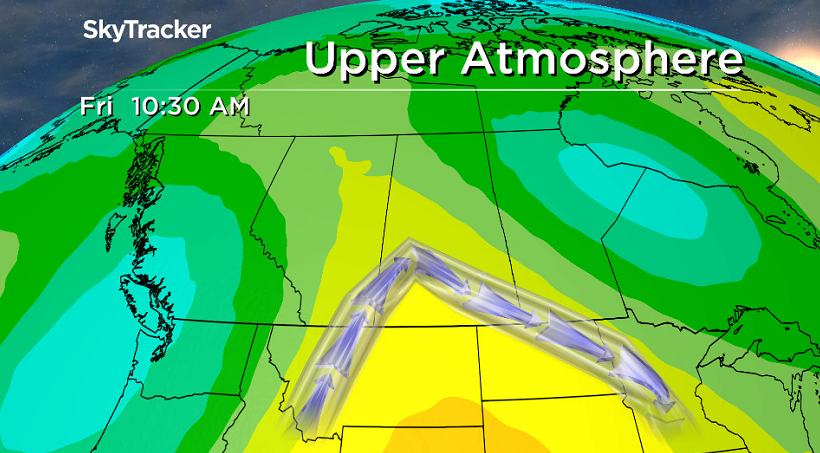
An upper ridge of high pressure looks to build in to end off the work week, bringing us back into some warmer air with daytime highs back into the low 20s.
That ridge will also help bring in some more sunshine for the rest of the week with some more clouds expected, particularly early on Thursday and later in the day on Friday and predominantly sunshine in between.
Weekend Outlook
A system swinging into Alberta will push in the clouds on Saturday with a slight chance of showers, but a better rain risk moves in on Sunday and into early next week.


Cooler air will slide in this weekend as well, dropping daytime highs from the mid-teens Saturday to the low teens on Sunday.


This Saskatoon Your Saskatchewan photo was snapped by Marilyn Wiggins:

Saskatoon weather outlook is your source for Saskatoon’s most accurate forecast and is your one stop shop for all things weather for central and northern Saskatchewan with comprehensive, in depth analysis that you can only find here.
Comments