

Cold air clears out and makes way for a big warm up with freezing rain likely.

Saskatoon Forecast
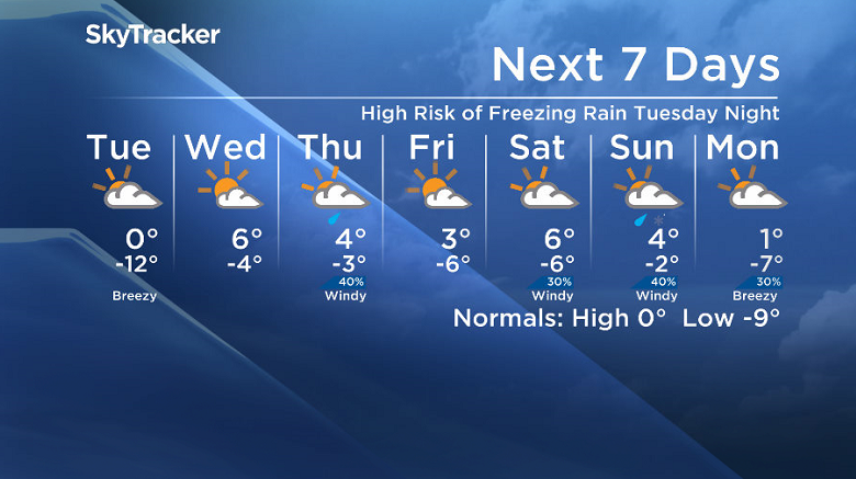
Today
-28 was what it felt like this morning in Saskatoon with wind chill as temperatures dipped back to -19.
A moderate southeasterly wind kicked in late morning that helped warm us up to -12 by noon.
Mostly cloudy skies that started our day will continue into the afternoon as we rise up into minus single digits for the first time in over a week.
Tonight
Mostly cloudy skies will stick around tonight with a very slight chance of flurries as the mercury slides back around -12 overnight.
Tuesday
-20 is around what it’ll feel like with wind chill tomorrow morning under mostly cloudy skies before we get into some sunny breaks into the afternoon before clouds return in the afternoon
The arctic ridge of high pressure that’s kept us cool is being shoved aside by a wave of warm, moist Pacific air, which will help warm us up toward the freezing mark later in the day.

Freezing rain is likely tomorrow evening into the overnight period as a wave of moisture associated with a warm front pushes through.

Wednesday-Friday
With freezing rain coating the ground overnight and temperatures falling a few degrees below freezing by morning, expect an extremely slippery Wednesday morning commute.
During the day on Wednesday, we’re expecting to warm way up above freezing to a high in mid-positive single digits under a mix of sun and cloud, which will help melt the ice that does develop.

A system is slated to slide through on Thursday that’ll kick up a chance of showers with a daytime high a few degrees above zero before cooling us back below freezing on Friday morning.


It does look like we may warm back up above zero under a mix of sun and cloud on Friday.
Weekend Outlook
There is still some uncertainty in the weekend forecast, however it looks like it’ll be windy with Saturday being very warm and well above freezing with a kick of heat ahead of a system that’ll slide through on Sunday and bring in a chance of mixed precipitation during the day as we cool back down below freezing.
Philippe Gaudet took this Your Saskatchewan photo on Highway 55 east of Prince Albert after last week’s wind storm:

Saskatoon weather outlook is your source for Saskatoon’s most accurate forecast and is your one stop shop for all things weather for central and northern Saskatchewan with comprehensive, in depth analysis that you can only find here.
Comments