

Extreme cold possible next week after some snow this weekend!

Saskatoon Forecast
Today
-27 was what it felt like this morning in Saskatoon with wind chill as temperatures fell back to around -20 early this morning under partly to mostly clear skies.
Clouds built back in during the morning with mostly cloudy skies by noon after warming into the mid-minus teens.
Partly to mostly cloudy skies will linger for the remainder of the day with the mercury rising up to around -12 or so for an afternoon high.
Tonight
Clouds will return tonight with a chance of flurries into the early morning hours as temperatures fall back a few degrees into the minus teens.
Saturday
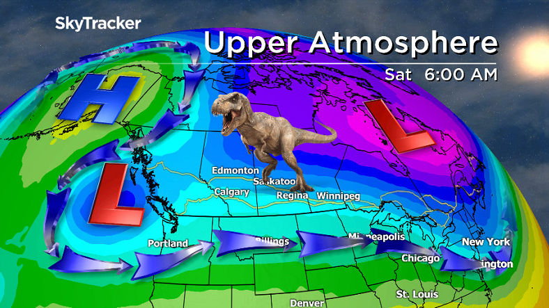
Daytime highs will continue to remain steady through the weekend and into next week in the mid-minus teens thanks to a Rex Block, blocking pattern in the upper atmosphere.
READ MORE: Rex Block holding pattern keeps Saskatoon cool
-26 is what it’ll feel like Saturday morning with wind chill under cloudy skies with a good chance of flurries, particularly in the morning as a low pressure system swings by south of the city.
Thermometers should climb up into the mid-minus teens for a daytime high in the afternoon hours, feeling like the -20s with wind chill all day.
Sunday

Arctic air tries to push in on Sunday, dropping temperatures back into the -20s in the evening with a chance of snow as a push of Pacific moisture tries to push north.
We are on the edge of the snow zone, so we’ll continue to keep an eye on the situation.


Work Week Outlook
Another pulse of moisture pushes in on Monday with snow likely once again under cloudy skies and a morning low in the mid-minus 20s with a daytime high into the minus teens.
Clouds will finally clear late Tuesday to give us mostly sunny skies mid-week as an arctic high drops us back into cool air.

Daytime highs will drop back into the low teens with lows down as low as -28 with wind chills approaching extreme cold warning criteria of -40 as we dive into the deep freeze mid-week.
This Your Saskatchewan photo was taken by Colin Chatfield near Saskatoon:

Saskatoon weather outlook is your source for Saskatoon’s most accurate forecast and is your one stop shop for all things weather for central and northern Saskatchewan with comprehensive, in depth analysis that you can only find here.
- Life in the forest: How Stanley Park’s longest resident survived a changing landscape
- ‘Love at first sight’: Snow leopard at Toronto Zoo pregnant for 1st time
- Carbon rebate labelling in bank deposits fuelling confusion, minister says
- Buzz kill? Gen Z less interested in coffee than older Canadians, survey shows
Comments