

Saskatoon has gone from -47 wind chills to record breaking heat in a week!

Saskatoon Forecast
Today
Exactly a week ago Saskatoon on Wednesday morning, Saskatoon was sitting at -47 wind chill values and just seven days later, we’re breaking temperature records that are 50 degrees warmer!

Mostly cloudy skies overnight combined with a southerly breeze and a ridge of high pressure over our area gave us a mild morning.
Temperatures only fell back to -1 overnight before rising up to +3 by morning with high cloud creating another stunning sunrise.
We then climbed up to +4 by noon with sustained southerly wind speeds picking up to around 30 km/h, helping mix down even warmer air.
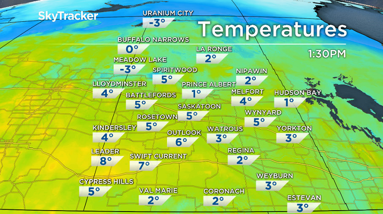
High cloud continues to slide over the region, sticking around for the rest of the day as we shoot up to an afternoon high around 5 degrees.
At 1 p.m., Saskatoon rose to 5.2 degrees, breaking a 94-year-old high temperature record for January 18 of 5.0 degrees from 1923!
Tonight
That high cloud will continue over the area tonight as the mercury falls back below freezing by a degree or so.
Thursday
Thursday is expected to be the hottest Jan. 19 ever recorded in Saskatoon as the high cloud continues to keep the city under mostly cloudy skies.
Temperatures are expected to reach 4 degrees for a daytime high, with the previous record of 3.3 degrees from 1971 likely to be surpassed by early afternoon.

There is a very slight chance of a few showers late in the day through the evening hours, but I’m not convinced that it’ll amount to anything at all, but it’s worth mentioning.
Friday
The ridge of high pressure in the upper atmosphere that’s kept us in the warm air all week is expected to stick around right until the end of the week, but slightly cooler air will move in on Friday.


Under mostly cloudy skies, our daytime high will likely be around +2, just shy of our record of 3.9 degrees from 1968 for that day.
Weekend Outlook
The trough associated with a system in the north-central United States will back into our area this weekend, bringing us back into the clouds and pushing in some snow late Saturday into Sunday.
At this point there is some disagreement on how much snow will fall, so we’re going with a fairly broad range right now of 2 to 8 centimetres possible, but we’ll pinpoint this as the date approaches.

Afternoon highs will fall back just below freezing through the weekend with lows back into mid-minus single digits.
Gord Zawislak took this Your Saskatchewan photo at Blackstrap Lake:

READ MORE: Get a 2017 Your Saskatchewan calendar today
Saskatoon weather outlook is your source for Saskatoon’s most accurate forecast and is your one stop shop for all things weather for central and northern Saskatchewan with comprehensive, in depth analysis that you can only find here.
Comments