

-18 was what it felt like with wind chill today, but there’s a little warm-up for the weekend!

Saskatoon Forecast
Today
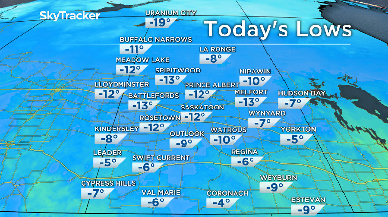
This morning was the farthest the mercury has fallen in Saskatoon since March 19.
-12 was where we started the day, but with wind chill it felt like -18 this morning under clear skies.
Partly to mostly sunny skies dominated the day from morning into the afternoon as the mercury pushed up to -5 by 1 p.m.
We’ll see some more clouds push in this afternoon with temperatures bumping up a few more degrees, expecting to reach -3 or so for a daytime high.
Tonight
It’ll be another chilly night under partly cloudy skies with temperatures once again dipping back into minus double digits.
Saturday
If you’re up bright and early Saturday morning, you’ll be greeted to wind chill values in the mid-to-low minus teens.
We may catch a few sunny breaks early in the day to kickoff the weekend, but the cloud cover will move in quickly after that as the next system develops in Alberta.
During the day we should warm up to a daytime high around -1 or -2, but with the wind chill it’ll still feel like mid-minus single digits right through the afternoon.
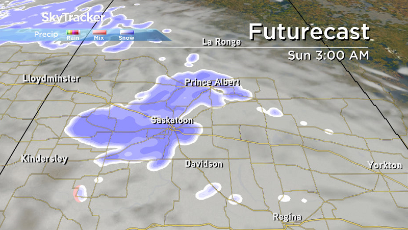
Then tomorrow night a low pressure system swinging through southern Saskatchewan will likely kick up some light snow into early Sunday morning.
Sunday
That light snow may linger into Sunday morning before it clears out and cloud cover sticks around until the afternoon when it begins to clear.
Another system will quickly form behind this system, helping to keep us a bit warmer on Sunday with temperatures expected to pop up above freezing in the afternoon.


Work Week Outlook
As that next system slides through on Monday we’ll see mostly cloudy skies and a chance of rain or freezing rain, depending whether the ground temperature is above or below freezing when the precipitation occurs.

Temperatures should climb above freezing that day before falling back below freezing for Tuesday behind the system under mostly cloudy skies.
We should see a warm-up back above freezing from Wednesday through Friday under a mix of sun and cloud for the most part.
This Your Saskatchewan photo was taken by Linda Phillips at Last Mountain Lake:

Saskatoon weather outlook is your one stop shop for all things weather for Saskatoon, central and northern Saskatchewan with a comprehensive look at your local forecast that you can only find here.
Comments