

Winter warnings for heavy snow in northern Saskatchewan today before remnants of a typhoon affect Saskatoon’s weather this weekend.

Weather Alerts
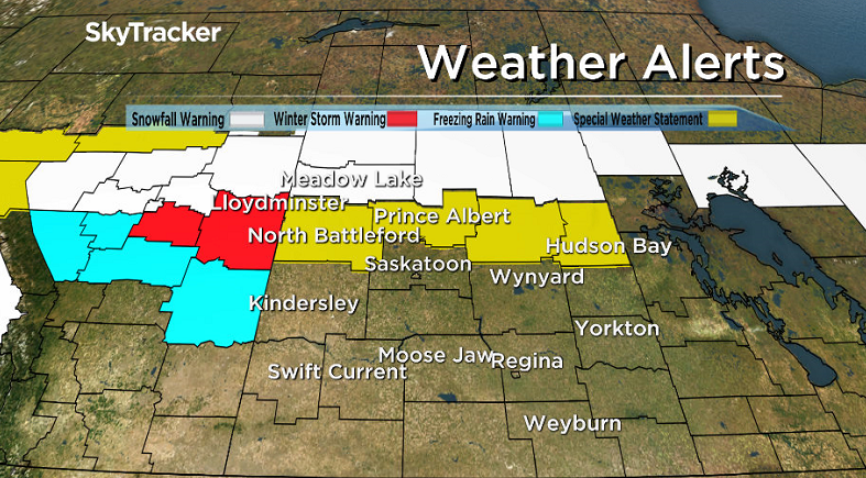
A winter storm warning has been issued for the city of Lloydminster for hazardous winter conditions expected.
Snow, freezing rain and ice pellets are expected with this system with the worst conditions expected Friday and up to 10 to 15 centimetres of snow possible before the heavy snow moves out of the area on Friday evening.
Environment Canada advises the public to consider postponing non-essential travel until conditions improve.
The agency has also issued a special weather statement for the Prince Albert, the Battlefords, Melfort and Hudson Bay areas for a weak low pressure system tracking through, followed by a stronger system on Friday with a mixture of precipitation types expected.
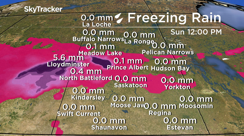
Radar shows precipitation moving into western Saskatchewan late Friday morning, and with temperatures in some areas just below the zero mark, brief freezing rain could occur into the early afternoon hours.
The area most at risk for this freezing rain is from Spiritwood west through the Battlefords and to the Alberta border.
As the system pushes east, the freezing rain will likely disappear with a rain snow boundary setting up north of a line from North Battleford to Prince Albert to The Pas.
Points south of this line should experience mostly rain, with perhaps one or two centimetres of snow behind the cold front Friday night.
North of this line snowfall amounts should increase rather quickly, with total amounts of 10 to 20 cm from Meadow Lake eastward through Flin Flon.
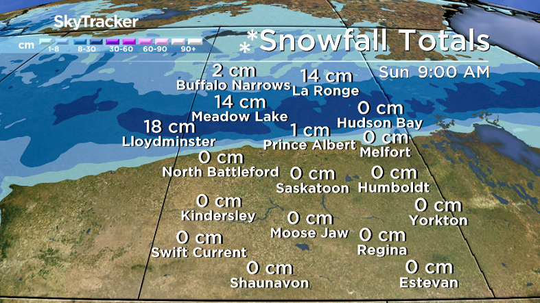
A snowfall warning has been issued in the Meadow Lake, La Ronge and Pelican Narrows areas for 10 to 15 centimetres of snow.
Snow associated with the system will begin early this afternoon and spread eastward during the day before it ends by Saturday morning.
For the latest weather alerts download the Global News Skytracker weather app for iPhone, iPad or Android.
Motorists planning to head out on roads are advised to use caution and check in with Saskatchewan Highway Hotline before heading out.
Saskatoon Forecast
Today
-2 was where temperatures started the day in Saskatoon, much milder than Thursday morning’s -9 degree start to the day, but there was a bite to the air with a wind chill of -6 making it feel much cooler.
Mostly cloudy skies started the day with rain associated with the low pressure system bringing snow and mixed precipitation to areas north of the city bringing rain into Saskatoon just before noon.
That light rain is expected to continue into the early afternoon before tapering later today.
Temperatures did climb to +1 by late morning and could climb up into mid-single digits for a daytime high today depending when the rain eases off.


Tonight
After the rain has eased off, mostly cloudy skies look like they’ll linger with a few periods of partly cloudy skies possible as temperatures dip back a degree or two below freezing overnight.
Saturday
The weekend will kick off on a mostly cloudy note tomorrow with just a slight chance of afternoon light showers as we sit between systems on Saturday.
After wind chill values make it feel like mid-minus single digits in the morning, temperatures will pop back up above freezing by up to 3 or 4 degrees in the afternoon.
Sunday
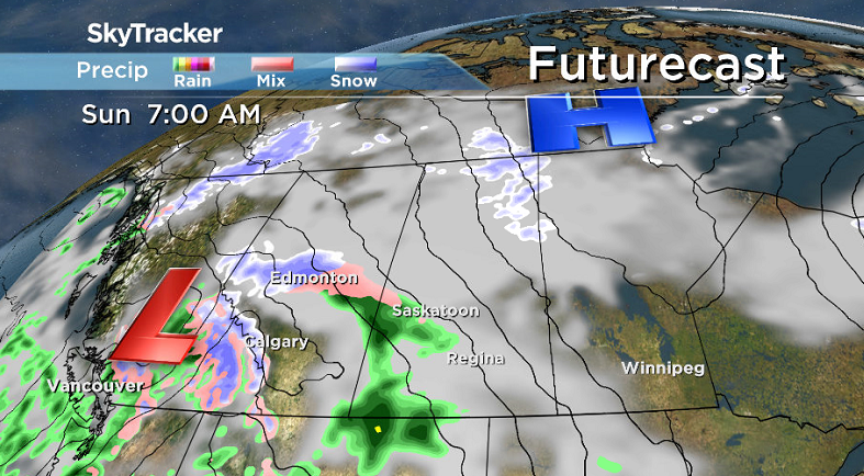
The remnants of Typhoon Songda will slam into Canada’s west coast late Saturday spawning the development of a low pressure system on the Prairies on Sunday that’ll bring in heavier rain to Saskatoon.
A push of milder air is also expected with the rain during the day that could push the mercury up into mid-single digits for a daytime high with wind gusts as high as 45 km/h possible along with sustained wind speeds as high as 30 km/h.
Work Week Outlook
Next week is shaping up to be a bit less wet and more settled under mostly to partly cloudy skies most days.
That’ll mean we’ll see a bit more sunshine with daytime highs to start the week in low-to-mid single digits before likely pushing up a bit higher toward the end of the week as we continue to see the snow melt across the region helping temperatures to recover as well.
Gwen Rudolph took this Your Saskatchewan photo at Turtle Lake:

Saskatoon weather outlook is your one stop shop for all things weather for Saskatoon, central and northern Saskatchewan with a comprehensive look at your local forecast that you can only find here.
- Canadian man dies during Texas Ironman event. His widow wants answers as to why
- On the ‘frontline’: Toronto-area residents hiring security firms to fight auto theft
- Honda’s $15B Ontario EV plant marks ‘historic day,’ Trudeau says
- Canadians more likely to eat food past best-before date. What are the risks?
Comments