
After the coldest day in over half-a-year, snow and rain will slide through Saskatoon ahead along with the remnants of a typhoon creating treacherous travel in areas heading into the weekend.

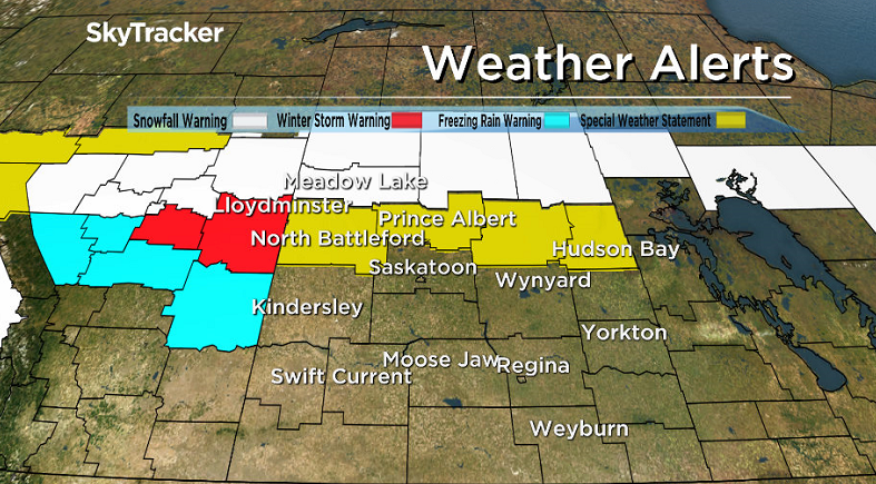
Weather Alerts
A winter storm warning has been issued for the city of Lloydminster for hazardous winter conditions expected.
Snow, freezing and ice pellets are expected with this system with the worst conditions expected Friday morning and up to 10 to 15 centimetres of snow possible.
Environment Canada advises the public to consider postponing non-essential travel until conditions improve.
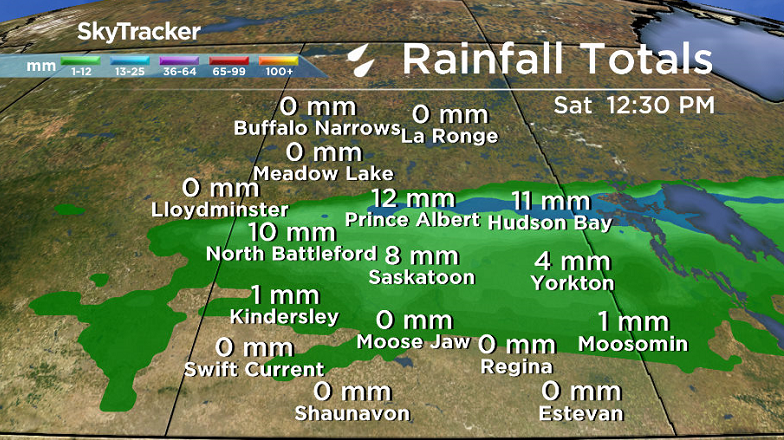
The agency has also issued a special weather statement for Prince Albert, the Battlefords, Melfort and Hudson Bay for a weak low pressure system tracking through, followed by a stronger system on Friday with a mixture of precipitation types expected.
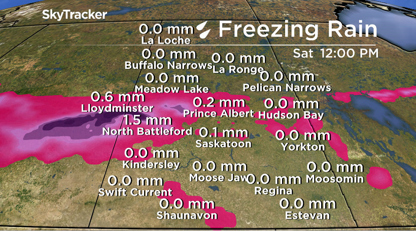
Some brief freezing rain could also occur especially over the Battlefords and Prince Albert forecast regions.
As the second system approaches on Friday morning, the risk of freezing rain will be a bit higher over the Battlefords and Prince Albert regions in the morning, but should transition to a rain snow mix in the afternoon.
Areas north of the Battlefords and northwest of Prince Albert could see a few centimetres of snow accumulate through the day on Friday and up to 10 cm are likely at Meadow Lake where a snowfall warning has been issued.
Travellers to Alberta should also note that freezing rain will begin earlier there than in Saskatchewan, and likely with higher amounts – thus warnings are in effect for Alberta.
A snowfall warning has been issued in the Meadow Lake, La Ronge and Pelican Narrows areas for 10 to 15 centimetres of snow expected.
Snow is expected to begin around noon Friday near the Alberta-Saskatchewan border and affect eastern Saskatchewan by Friday afternoon.
The heaviest snow will begin to taper off Saturday morning.

The next low pressure system is stronger and will spread snow and freezing rain into the Lloydminster region with up to 15 centimetres possible as the system intensifies and tracks eastward.
Freezing rain will change to rain as the warm front pushes northeast Friday afternoon and end by evening as the system moves into Saskatchewan.
For the latest weather alerts download the Global News Skytracker weather app for iPhone, iPad or Android.
Motorists planning to head out on roads are advised to use caution and check in with Saskatchewan Highway Hotline before heading out.
Saskatoon Forecast
Thursday
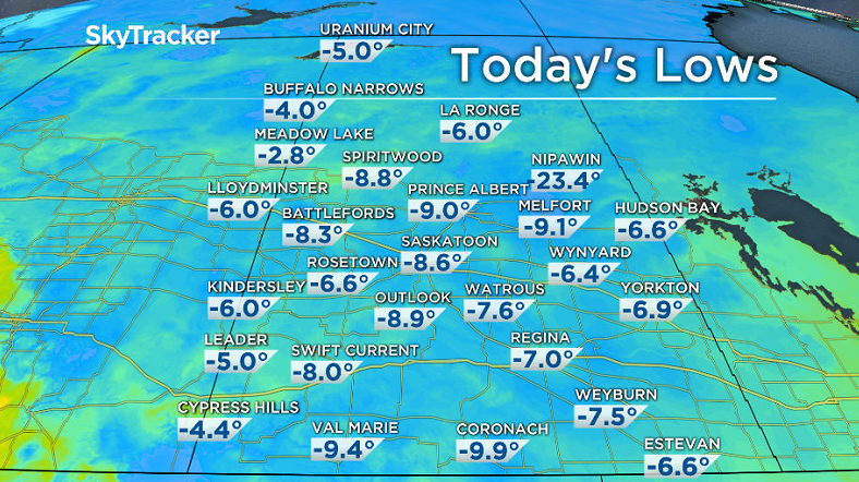
-13 was what it felt like Thursday morning with temperatures dipping down to -9, the lowest it has dropped in over half-a-year.
You have to go back all the way to April 11 to see the mercury drop back that low.


Mist and fog patches started the day with some sunshine in the morning and a mix of sun and cloud through the middle of the day helping temperatures rise up to the freezing mark by the noon hour.
Thursday afternoon clouds rolled back in as a moderate southwesterly wind picks up at sustained speeds around 20 gusting to 40 km/h at times.
As a result, warmer air will mix down, allowing us to push up above freezing by a few degrees.
Thursday Night
More moisture will push through tonight with some wet snow changing over to rain expected this evening, easing off overnight as temperatures dip back to around -1.
Friday
Wind chill values will make it feel like mid-minus single digits Friday morning.
Mostly cloudy skies will stick around through the day Friday with a good chance of rain from mid-morning into the afternoon as temperatures push up to around 6 or 7 degrees for a daytime high.
Weekend
Saturday looks like it’ll be mostly cloudy with a daytime high in mid-positive single digits.
On Sunday, the remnants of Typhoon Songdo crashes into the west coast pushing moisture across the Rockies onto the prairies resulting in a low pressure system swinging through that’ll bring in rain, cloud cover and wind through the day.
Despite the precipitation, we should still manage to hit a daytime high around 6 or 7 degrees as the system will also come with a push of heat.
Work Week Outlook
Next week is shaping up to be a bit sunnier with partly to mostly cloudy skies and daytime highs back into mid-single digit territory.
This Your Saskatchewan photo was taken by Angelina Wiebe at Gruenfeldt:

Saskatoon weather outlook is your one stop shop for all things weather for Saskatoon, central and northern Saskatchewan with a comprehensive look at your local forecast that you can only find here.
- Canadian man dies during Texas Ironman event. His widow wants answers as to why
- On the ‘frontline’: Toronto-area residents hiring security firms to fight auto theft
- Honda’s $15B Ontario EV plant marks ‘historic day,’ Trudeau says
- Canadians more likely to eat food past best-before date. What are the risks?
Comments