
WINNIPEG — A major disturbance originating in southeastern Montana will be bringing some wicked weather to parts of Manitoba.

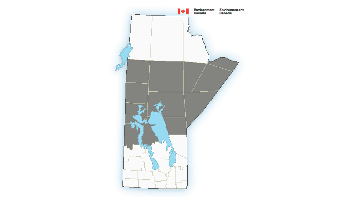
Environment Canada has issued a special weather statement for the central and northern parts of our province, saying to expect rain and snow through the end of the week.
The system will also bring plenty of rain and even snow to parts of southern Saskatchewan.

Most of southern Manitoba will predominantly be hit with rain beginning Tuesday but cooler temperatures are most definitely on the way for Winnipeg.
The precipitation will start later Monday afternoon and intensify as it tracks northward and gains strength.
These areas could see anywhere between 50 and 75 mm. of rain by Thursday afternoon.
Arctic air will become part of this system by late Tuesday and that rain could turn to snow for areas north of a line from Flin Flon to Nelson House and South Indian Lake.
15 to 30 cm. of snow is possible through Thursday afternoon, with Lynn Lake getting the brunt of the snowfall.


The good news is that most of this snow will likely melt due to ground temperatures still being rather warm.
Winds will also be gusty out of the northeast up to 70 or 80 km. per hour as the system moves through.
If you’ll be travelling west over the next couple of days it’s important to note what’s happening in Saskatchewan.
Southern Saskatchewan will also be hit with plenty of rain with the southwestern portion getting hit the hardest with 50 to 75 mm. to fall.
Snow will fly over higher elevations like Cypress Hills with 5 to 10 cm. possible. Again, most of the snow melting due to the warm ground.
Here is the list of areas expected to see excessive rain and/or snow:
- Flin Flon – Cranberry Portage – Snow Lake
- Gillam
- Grand Rapids – Waterhen
- Island Lake – Oxford House – Gods Lake
- Lynn Lake – Leaf Rapids – Pukatawagan
- Norway House – Cross Lake – Wabowden
- Poplar River
- Shamattawa
- Swan River – Duck Mountain – Porcupine Provincial Forest
- The Pas – Wanless – Westray – Clearwater Lake Prov. Park
- Thompson – Nelson House – Split Lake
- York
It is possible for conditions to change over the next couple of days and Global News will update accordingly.
- Budget 2024 failed to spark ‘political reboot’ for Liberals, polling suggests
- Train goes up in flames while rolling through London, Ont. Here’s what we know
- Peel police chief met Sri Lankan officer a court says ‘participated’ in torture
- Wrong remains sent to ‘exhausted’ Canadian family after death on Cuba vacation
Comments