

UPDATE: Special weather statement for heavy rain and strong wind into Saturday has been ended for Saskatoon, but remains in place for eastern Saskatchewan.

Special Weather Statement
Environment Canada has continued a special weather statement for Regina and portions of southern and eastern Saskatchewan for a wet start to fall.
The culprit for the douse of rain will be a large and slow-moving storm system over the western United States that will move towards the Saskatchewan-Manitoba border over the weekend.

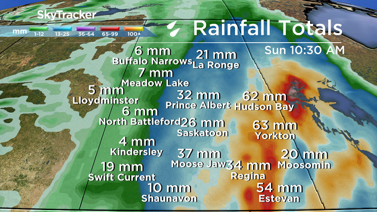
As of 8 a.m. CT, upwards of 30 millimetres of rain was reported in parts of southern Saskatchewan.
The rain started around 7 a.m. in Saskatoon with 8 millimetres recorded in the city by noon.
This system will bring a prolonged period of rain across much of southern Saskatchewan from the end of the work week into the first weekend of fall.

The first wave of rain from this system pushed into southwest Saskatchewan Thursday morning, becoming more widespread over southern Saskatchewan into Saturday.
Rain is expected to continue Saturday, locally heavy at times, before it tapers off from west to east on Sunday.
In general, most areas of southern Saskatchewan should be seeing 30 to 50 mm of rain by late Saturday with localized amounts of 50 to 80 mm possible over portions of southwest Saskatchewan northeast towards the Hudson Bay region.

Rainfall warnings may be issued for areas which see 50 mm or more within 24 hours or 75 mm or more within 48 hours.
In addition, strong northwest winds are expected to develop behind this storm system Saturday into Sunday, with gusts of 60 to 70 kilometres per hour possible.
For the latest weather alerts download the Global News Skytracker weather app for iPhone, iPad or Android.
Saskatoon Forecast

Today
The rain moved into Saskatoon around 7 a.m. this morning and continued steadily right into the afternoon hours.
Temperatures dipped back from 12 around midnight, down to 8 degrees this morning with east-southeasterly winds at sustained speeds upwards of 35 km/h and gusts into the 40 to 50 km/h range at times.
Winds will remain around that threshold through the afternoon with the mercury staying in high single digits, possibly tipping into low double digits at times as the rain continues – heavy at times – for the remainder of the day.
Most models are suggesting around 15 millimetres of rain will fall in the city today with higher amounts southeast of the city.


Tonight
Rain will ease a bit tonight giving us a bit of a break, but there’s still a chance of showers in the forecast as temperatures dip back into single digits.
Saturday
Saturday will be a bit of a miserable day.
The low pressure system responsible for the rain swings by southeast of the city on Saturday bringing back in the rain throughout the day.
Most models are indicating that we’ll see another 10 to 15 millimetres through the day as an upper trough digs in under cloudy skies.
It will be a cool, windy day with temperatures only reaching low double digits once again and winds strengthening through the day up to sustained northerly speeds around 40 km/h with gusts upwards of 60 km/h at times.
Sunday
Conditions improve exponentially for Sunday with a return to the sunshine behind the system as a ridge of high pressure builds back in.
Despite the windy and cool start to the day around 3 degrees, temperatures will rebound back into the mid-teens for an afternoon high.
Work Week Outlook
The upper ridge continues building in early next week, keeping us in the sun right into the middle of the week when a system starts moving through.
Daytime highs will be very summery to start the first full week of fall with temperatures topping out in the low 20s until mid-week when they dip back into the teens.
This Your Saskatchewan photo was taken by Tyrell Matzner in Leoville:

Saskatoon weather outlook is your one stop shop for all things weather for Saskatoon, central and northern Saskatchewan with a comprehensive look at your local forecast that you can only find here.
- Trudeau tight-lipped on potential U.S. TikTok ban as key bill passes
- Canadian man dies during Texas Ironman event. His widow wants answers as to why
- Hundreds mourn 16-year-old Halifax homicide victim: ‘The youth are feeling it’
- On the ‘frontline’: Toronto-area residents hiring security firms to fight auto theft
Comments