
When you look at Canada as a whole, the winter of 2015-2016 could be one of the warmest in recent memory. This will be in stark contrast to the last two brutal winters. In fact, Canada has only seen one mild winter out of the past five with none since 2012.

With colder weather fast approaching, the big question everyone is asking “will this winter be anything like the last two”?
The short answer is, no. While there will be outbreaks of Arctic air, we do not expect another lengthy stay from the polar vortex like in 2013 or have the coldest February on record like last winter across eastern Canada. In fact, signs point to a back-and-forth winter with cold coming and going rather than locking in. Overall, 90 per cent of Canada may end up with warmer-than-normal temperatures this winter.
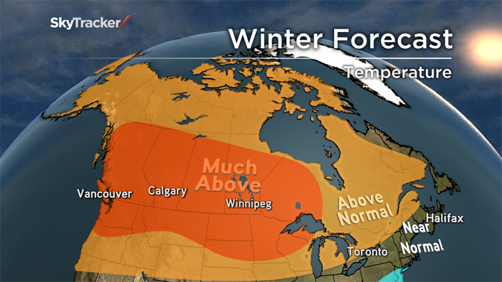
Where will the coldest and warmest places in relation to normal be across Canada?
We are forecasting very mild air for the western half of Canada with Chinook winds centering the warmth in Alberta where it could be one to three degrees above normal this winter. The coolest spot (in relation to normal) is likely to be across southern Ontario where a trough will set up for much of the winter and temperatures will average only slightly above seasonal.
READ MORE: Saskatchewan RCMP rhyme about winter road safety
How much snow are we expecting?
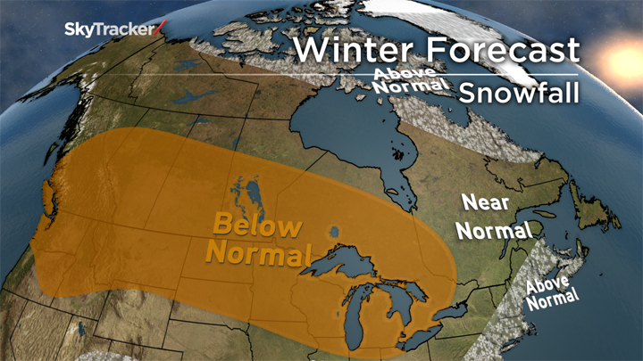
Good news for the mountains in western Canada, the ski season is getting off to a great start with huge snowfall totals already, and more on the way in the next few weeks. Unfortunately, the natural snow guns may shut off later in the season as the jet stream shifts south.
The Prairies and Ontario will see below normal snowfall with most of the precipitation generated from fast-moving Alberta Clippers. That would mean several smaller five-centimetre storms rather than the big 20-centimetre-plus Colorado Lows.
WATCH: Global’s chief meteorologist gives us a look at what we can expect this winter
For areas further east including most of Quebec and the Maritimes, a few significant Nor’easters will bring snowfall closer to average or slightly above. This winter will be known for a strong southern jet stream and storm track, and that should leave the Canadian snow-lovers wishing for more.
The last time the El Nino was this strong was in 1998. Are we expecting another “ice storm of the century” like in 1998?
El Ninos are known for a stronger southern jet stream which is often packed with moisture. In 1998, this jet delivered record precipitation over eastern Ontario and Quebec while the polar jet was supplying fresh Arctic air. The end result was a crippling five-day ice storm.


- Life in the forest: How Stanley Park’s longest resident survived a changing landscape
- Bird flu risk to humans an ‘enormous concern,’ WHO says. Here’s what to know
- Roll Up To Win? Tim Hortons says $55K boat win email was ‘human error’
- Election interference worse than government admits, rights coalition says
The risk of big freezing rain events do increase across Ontario and Quebec in El Nino years, but this does not mean the region will see another devastating “once-in-a-lifetime” storm where everything came together perfectly like in 1998. Another crippling ice storm impacted the Greater Toronto Area right before Christmas in 2013 leaving hundreds of thousands in the dark for days, but that was not an El Nino year.
READ MORE: First shot of winter brings traffic chaos to Winnipeg
What are the chances of a white Christmas?
With below-normal snowfall and much above-normal temperatures forecast for December, the likelihood of a white Christmas is lower than average this year for most of Canada. The good news is that it only takes that one small storm to bring a blanket of white in time for the holidays, and forecasting individual systems are impossible this far in advance.
What other factors will influence the weather this winter?
There has been lots of talk about El Nino and how this is one of the strongest on record. El Nino intensifies the southern jet stream. While El Nino will certainly affect the winter ahead, it’s not the only factor at play.
READ MORE: 5 things to know about El Nino, coming to Canada this winter
Warm water off the east coast should mean powerful Nor’easters up the coast and for Atlantic Canada. This warm water can also help draw in cold Arctic air towards the coast and could bring a slow start to spring.
The past two winters have had a warm blob of water off the west coast which has helped pump a big ridge of high pressure to the Prairies and led to very dry, mild winters in B.C. while the rest of Canada froze. While the water isn’t as warm off the coast, this could still be a factor throughout the winter. Early season snow cover in Canada and across the ocean in Asia are also looked at as signs to the type of winter ahead.

Comments