
Weather update: Wednesday April 15, 2015 4:30pm

Make outdoor plans as we have a beautiful weekend ahead!
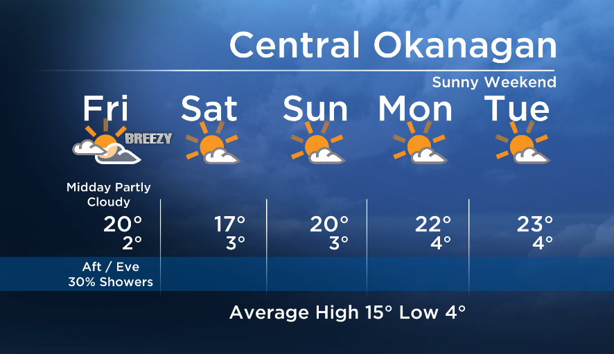
As for Friday – the northern areas will see more cloud with average conditions, whereas the southern portions will see brighter conditions and above seasonal temps.
Shuswap/Columbia: Expect a mix of sun and cloud with increasing cloud midday with a slight risk of a shower for the regions as a weakening cold front crosses the area.
Okanagan: High cloud will move in midday with the passage of the weak front but we are not expecting any measurable precip. Areas in the South Okanagan and Boundary regions will be too far south and will see very little, if any, effect from the cooler air moving through.


An upper ridge will strengthen over our region for the weekend and into next week to bring back mainly sunny conditions and warmth by the weekend.
Friday’s daytime high range: 16 to 23C
More details coming up at 5, 6:30 and 11pm!
~ Duane English / Wesla Wong
- Life in the forest: How Stanley Park’s longest resident survived a changing landscape
- ‘Love at first sight’: Snow leopard at Toronto Zoo pregnant for 1st time
- Buzz kill? Gen Z less interested in coffee than older Canadians, survey shows
- Carbon rebate labelling in bank deposits fuelling confusion, minister says
Comments