
Weather update: Thursday January 22nd 5am

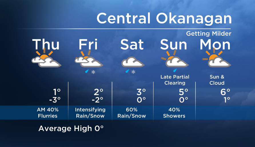
The flattening of the upper ridge over BC will open the door to multiple systems, and we will see precipitation on and off over the next few days.
Our temperatures will also gradually warm up as these systems will tap into subtropical moisture that will also bring mild air causing freezing levels to rise.
The first wave arrived this morning and will be the weakest with just a slight chance of flurries.
The next wave will move in tomorrow afternoon and evening bringing more widespread rain or snow to the valley Friday night and Saturday.


Another feature will push onshore on Sunday, keeping showers in the forecast for the second half of the weekend.
We will return to a drier weather pattern after the weekend.
Hope to see you tonight at 5, 6:30 and 11pm!
Today ‘s daytime high range: -2 to 4C
~ Duane/Wesla
- Canadian man dies during Texas Ironman event. His widow wants answers as to why
- On the ‘frontline’: Toronto-area residents hiring security firms to fight auto theft
- Honda’s $15B Ontario EV plant marks ‘historic day,’ Trudeau says
- Canadians more likely to eat food past best-before date. What are the risks?
Comments